 |
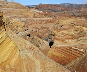
| Perhaps you've seen this image on the cover of a "Scenic America" book or calendar. It's even better in person. |
 |
| Giant "Cinnabons" like these line the trail on the way to Coyote Buttes North. |
 |
| Tim stops to compose a shot of this natural playground. |
 |
| We discovered the ideal lunch spot—atop these sun-warmed rocks on a cold winter day. |
 |
| When you find yourself standing in a spot like this, remember to thank the wind. |
 |
| This view shows the terrain traveled on the way to "The Wave". |
The 2.5 mile hike to Coyote Buttes North crosses sand and slickrock. Visitation is limited in this fragile area and a permit is required for those wanting to access the trail. Contact the Bureau of Land Management (BLM) office in Kanab, Utah for more information.
And, just a reminder, desert hikes can be deadly in hot weather. This sobering post is proof of that sad fact: https://onedayinamerica.blogspot.com/2013/08/death-in-utah-desert.html

Rita, I must lead a very sheltered life! :-) Your blog is the first place that I've ever heard of Coyote Buttes, and I certainly don't recall ever having seen photos of this magnificent place with its unreal beauty. Thanks for sharing! I really do need to travel more and broaden my horizons!
ReplyDeleteYour photos are super-superb!
John
Hi John,
DeleteI believe that some variation of the first photo in this report is on the cover of a Reader's Digest Scenic America book (published in the 1980's?). So I don't blame you if you haven't seen that one!
If you're in need of a horizon-broadening place, Paria Canyon and Coyote Buttes are the perfect venues!
Thanks for the compliments!
Amazing territory - it looks like you could surf those undulating "waves." I love these places where wind carves the sandstone and will now add Coyote Buttes to my must-see list.
ReplyDeleteYour gorgeous photographs really capture the beauty of these swirling lines!
Hi Vickie,
DeleteSurfing those waves? I'm sure if they let kids with their skateboards in there, they would try it! (That's why they don't let them in...)
Coyote Buttes is a must-see place. Permits for the popular months—spring and fall—are difficult to get. I would recommend a winter visit.
As always, I appreciate your comments and compliments!
How many acres is this wilderness area? And are there buttes covering the whole preserve or just in a certain spot?
DeleteThanks!
Hi again Vickie,
DeleteThe Paria Canyon/Vermillion Cliffs wilderness encompasses 112,500 acres. The buttes and other wind-sculpted rock formations are mostly confined to the northwest portion of the wilderness. Maps of the area may be obtained from the BLM (Bureau of Land Management).
A good home base for exploring this area is the Utah town of Kanab; the BLM field office is located in Kanab as well.
Hope this info helps with any trips you may be planning!
My goodness, that's a lot of acreage!
DeleteThanks for all these great tips. It's very helpful to know about good places to venture out from!
Somehow, I seem to have missed this post. Happy to have been guided by your latest.
ReplyDeleteAs much awesome as your pictures are Rita, the efforts you have taken to record these astonishing natural phenomena, especially things like selecting the camera angle and distance are no less remarkable, one must say.
Sandstone lends itself to being carved rather easily and one is reminded of the rockcut temples of ancient India, some of them having been carved of sandstone.
Thank you for those amazing pics!
Thank youu for sharing
ReplyDeleteYou're welcome, Claire. I'm happy you enjoyed the post.
ReplyDelete