Tuesday, April 24, 2012

Visiting Rosalie and The Burn Plantations in Natchez, Mississippi


 "Welcome to Mississippi, It's Like Coming Home."
           Mississippi’s state slogan is one of the best and I found myself at home in Natchez while visiting two plantations which escaped the Union Army’s torches during the Civil War—Rosalie and The Burn.
           I arrive at The Burn Antebellum Bed and Breakfast on a bright spring afternoon and meet my hostess, Bridget Green, who shows me to my room and arranges for a personal tour of the home.  The Burn was given its unusual name by a Scottish gardener and refers to a babbling brook on the property, the word “burn” meaning “small stream or brook” in Old English and Scottish.  Antebellum—great word by the way—is of Latin origin and means "before the war".  In the southern United States "the war" means only one thing:  The Civil War.

Enjoy southern hospitality at
The Burn Antebellum Bed and Breakfast.
           I have time for an early dinner before my tour and I choose the Magnolia Grill in the Under-The-Hill district on the Mississippi riverfront.   My entrĂ©e of red fish almondine and fried sweet potatoes is tasty but my favorite part of the meal?  Two large glasses of sweet tea.

View of the Mississippi River from the Under the Hill
District in Natchez.

  After dinner I return to the B&B and meet my tour guide Nell, an employee of the B&B.  Nell serves me a glass of wine while I relax in the dining room and examine the pictures on the wall.  Nell returns and introduces me to the people in those pictures.  I meet John Walworth—original owner of The Burn—and his oldest surviving son Douglas, daughter Laura and her children, and daughter Lucy who died of yellow fever in 1853 at the age of 11.  Through the years many descendants of the Walworth family have called The Burn their home.
One outstanding feature of the home is an unusual semi-spiral freestanding staircase.  The floors, most of the window glass, and all the molding in the rooms are original to the house, along with the dining room table and china.  The tour continues outside.   Azaleas are blooming, two large fir trees stand guard over the rear patio, and a giant Live Oak graces the circular driveway. The Burn, a historical treasure, is the oldest original plantation in Natchez.  

Semi-spiral free-standing staircase
in The Burn's center hallway.

Large Fir Trees guard the rear entrance
to The Burn.

           After the tour I retire to my room, The Douglas Room, in a building called the Garconierre.  This building, just a few steps away from the main house, was built to house the sons of the family after they reached the age of fourteen.  In the antebellum south it was common practice to house teenaged sons in the Garconierre; the families could remain ignorant of the boys’ shenanigans and the boys' behavior didn’t disrupt the household.  
  I’ll bet there are more than a few families today who could benefit from having a Garconierre on the property.
                                                              ****
The following morning I wake to birdsong, having spent a restful night in The Douglas Room—no teenaged monkey business occurring in the Garcionerre last night!
Hot coffee waits for me in a silver coffee server on the buffet table in the dining room.  I pour a cup and take a seat at the head of a long table in this cavernous room with two fireplaces. I’m the only guest of the inn today but that doesn’t prevent the staff from serving a breakfast feast.  The meal starts with fruit boiled in a sugary syrup and continues with eggs, bacon, grits, OJ and sesame seed rolls—a perfect way to greet the day.
After breakfast I drive the short distance to Rosalie Plantation where a docent greets me on the front porch of the mansion for the 10 o’clock tour.  I learn that Rosalie was built by a native Pennsylvanian; he came to Mississippi in the early 1800’s and made his fortune in the timber business.  

Opulence in the deep south.  Rosalie Plantation.

The Daughters of the American Revolution bought the mansion in the 1960’s and have retained many furnishings and period pieces from the mid-1800’s.  The home is large and lavish.  It’s hard to believe that some people lived so elegantly during that period of our nation’s history while others lived as homesteaders in meager claim shanties.
Like the Burn, Rosalie was not destroyed during the war.  Rosalie’s superb location—high on a bluff overlooking the Mississippi River—led to its status as one of the Union Army’s headquarters.
And how did The Burn survive?  The Union Army occupied the home and used it as a hospital for three years during the war. Sure enough, there’s a photo inside the home of Union Army soldiers posing on the front porch of The Burn.
While both these plantations represent a dark period in our nation’s history, the buildings themselves are remarkable examples of architecture and elegance in the antebellum south.  

Plantations which could benefit the Union Army stood a better
chance of surviving the war unscathed.
From this photo you can see why the Rosalie was chosen
for it's excellent vantage point on the Mississippi River.

                                                     ****
You can find more information on Natchez, Mississippi by visiting this site:  http://www.visitnatchez.com/
Go on and make yourself at home in Mississippi.  Visit The Burn—here’s their web address: 
http://theburnbnb.com/ 

If you would like to read about a visit to another of the south's fascinating plantations, see this previous post:   http://onedayinamerica.blogspot.com/2011/03/cane-river-country-louisiana.html

Tuesday, April 17, 2012

Horse Thief Canyon Trail in Utah's San Rafael Swell


           In the silence we can still hear hoofbeats pounding and see dust clouds swirling from herds of stolen horses thundering their way through this desert canyon.

                                                           ****
          Once a staging area for horse thieves and cattle rustlers, the Old Smith Homestead in Utah's San Rafael Swell is now used to stage a more benign activity—hiking Horse Thief Canyon.  
          The 1880's Smith Cabin is also rumored to have been one of the many hideouts of Butch Cassidy and his gang.  Does a locale exist in the intermountain west that hasn't laid claim to hosting the Wild Bunch during their criminal careers?

Smith Cabin—Home to Nefarious 1800's Activities.
 To view another Butch Cassidy haunt—mentioned in a previous post—click here.

            Unlawful activities far from our minds, two friends and I begin our Horse Thief Canyon hike in a sandy wash through a desert bursting with color.  Cactus and desert wildflowers bloom in reds, oranges, yellows, pinks and purples, their hues complemented by the cream and coral sandstone rock walls surrounding the canyon. 


The brilliant red blooms of the Claret Cup Cactus—considered

one of the desert's most beautiful plants.

Plains Prickly Pear Cactus.

Plains Prickly Pear Cactus plants take root in cryptobiotic soil.

To learn more about the fragile ecosystem of cryptobiotic soil, 
click here.

Orange Globemallow.

Scalloped Phacelia, Scorpionweed.


          We hike for a couple hours and then climb out from the wash to find table-top rocks perfect for a lunch stop.  The setting affords panoramic views of our surroundings—from the Book Cliffs area of eastern Utah to the Henry Mountains of south-central Utah.

          After lunch we turn to retrace our steps and peer across the vast expanse of rock and sky.  Everything looks familiar and nothing does.  With a sense of dread we realize we've lost the trail.  Where did we exit the wash?  We follow a series of rock cairns leading to steep drop-offs over cliff edges.  After more climbing up, over and around groups of rocks we find a cairn we'd seen on the way to our lunch spot. Descending from this cairn delivers us into the correct canyon and back onto our trail.


Rita and Robin begin the return to the trailhead.
But wait?  Where is the route back into the canyon?

Cairns—(a mound of rough stones built as a landmark)
such as these guide hikers across slickrock.

Returning to the trailhead we re-live the tense moments before finding the trail; we've learned a sobering lesson today: It’s easy to become disoriented when hiking the San Rafael Swell and we were ill-prepared to spend the night in the desert.   
Relieved now, we enjoy a little laugh.  After all—if cattle rustlers and Butch Cassidy could navigate and survive in this harsh environment, well, maybe we could have done it too.  
       
                                                            ****
            
           Shade is non-existent on the Horse Thief Canyon Trail so it’s wise to hike this trail on a cool spring day.  The best time of year for wildflower viewing and photography in this area is (typically) the middle of May.  HIking the canyons, washes and slickrock of the San Rafael Swell can be fun—just don’t get lost.
The San Rafael Swell is a remote desert region in southeastern Utah.  You can learn more by visiting these websites:  http://www.sanrafaelswell.org/indexnew.html
http://www.blm.gov/ut/st/en/fo/price/recreation/SanRafaelDesert.html

                                                           ****
            Enjoy these flower photos from a subsequent visit to Horse Thief Canyon:


Hedgehog Cactus.


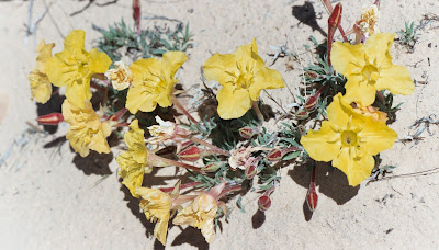
Lavender Evening Primrose—so named because the yellow flowers
fade to shades of orange or lavender upon drying.


Dwarf Evening Primrose.


Yellow Plains Prickly Pear.

Tuesday, April 10, 2012

Golden Throne Trail in the Land of the Sleeping Rainbow (aka Capitol Reef National Park)


          The Indians called it “Land of the Sleeping Rainbow”, this place where ridges of multicolored rock salute the sky.  These slopes, ledges and cliffs created impassable barriers to westward migration for white settlers; they termed the formations “reefs”.  Soaring sandstone domes reminded early explorers of our nation’s capitol dome.  And thus... the “sleeping rainbow” moniker was laid to rest and this land of colorful cliffs and twisting canyons re-christened Capitol Reef National Park. 

Land of the Sleeping Rainbow or Capitol Reef?
You decide.

Tim and I are visiting Capitol Reef for the day trying to decide which trail to hike, and it’s like choosing a topping for your ice cream sundae—no matter what you pick, you know you’re in for a treat.  
The drive to Golden Throne Trailhead is an adventure in itself.  The dirt road, surrounded by desert-varnished walls rising from earth to sky, hugs rocks and dips through washes.
We arrive at the parking area and are surprised by the number of cars.  Capitol Reef, Utah’s least visited national park, has been discovered.  Two trails may be accessed from this point:  Golden Throne and Capitol Gorge.  Golden Throne, our choice for the day, climbs 1100 feet in two miles and leads to a view of the trail’s namesake—a red/orange sheer-faced butte.  


Start here, climb 1100 feet, (a moderate climb)
and leave the crowds behind.

The crowded parking and picnic area for the Capitol Gorge
and Golden Throne trails.

We begin our hike and leave the crowds behind.  Dozens of lizards accompany us on our climb, darting across the trail and scurrying over and under rocks. Our trek transports us around four canyons; scoured over the millennia by rainstorms, these gullies now teem with vegetation and sculpted rocks.   We reach the top with its view of the Golden Throne and relax on the smooth rocks, enjoying the gentle breezes on this radiant day in the land of sleeping rainbows.


A side-blotched lizard scampers onto a rock to
have a look at us.


Indian Paintbrush in bloom along the trail.


Tim hikes toward the Golden Throne.

Rita gazes at the Golden Throne.  I'll bet the Indians
had a better name for this rock too.

View from the top of the trail looking east
toward the Henry Mountains.

An excellent companion guide for day-hiking Utah’s five national parks is 50 Best Short HIkes in Utah’s National Parks by Ron Adkison.

Readers, have you been to any of Utah's five National Parks?

For more information on Capitol Reef National Park, visit this website:  

Links to previous posts about Utah’s parks:

Tuesday, April 3, 2012

Sage Grouse Mating Ritual: View It While There's Still Time


              Pure pageantry in motion—that’s my description for the Sage Grouse’s annual mating ritual, and male grouse provide both the percussion and the costumes for this stunning April spectacle.  As the male struts and inflates his air sacs a low, barely audible “whoomp, whoomp” can be heard, like the slow steady beating on a tom tom.  The bird then flashes his tail feathers, a striking display of yellow-tipped, black and brown plumage. 


Male Sage Grouse about to inflate his air sacs
and serenade us with his drum solo.


Mr. Sage Grouse sports a beautiful white fur collar.

            Early on a spring morning Tim and I joined a Division of Wildlife Resources specialist and several other people in an open sagebrush meadow near Price, Utah.  Through our spotting scopes we observed 20 males and one hen on the lek, or “a patch of ground used by the males for communal display during the breeding season”.  
           The beauty of these grouse and the elegance of the performance unfolding in front of us were mesmerizing.  So much so that for the next several years in mid-April we arose at 5:30 a.m. to spend an hour or two in the presence of these resplendent game birds. 


Males assemble on the lek with hopes of attracting a mate.


Goodbye Mr. Grouse: the yellow tips on his tail feathers are barely visible—
but we could discern them through the spotting scope.

                                                     ****
         100 years ago over 16 million sage grouse could be seen on leks throughout the west.  Today that number is down to 200,000 and dropping rapidly.  Unfortunately for the sage grouse oil and gas production, agriculture, and human habitation is exploding on the low, flat sagebrush meadows the grouse need for reproducing.  It’s likely that the Sage Grouse will not make it through this century.  I consider myself fortunate to have witnessed one of wildlife’s most captivating shows—the sage grouse mating ritual.    
           This grand display may still be observed in remaining scattered sagebrush meadows throughout the intermountain west (see map below).  


Tim looks for sage grouse on a low-lying sagebrush meadow.


Map courtesy: Dr. M. Schroeder, Washington Department of Wildlife.  Taken from US Department of Agriculture (USDA) website.
                                                                                                                                                                      
         For information on Sage Grouse mating areas, contact the state Divisions of Wildlife in the regions shown on the map above.
         Are you interested in helping to protect the Sage Grouse?  Please visit this website:  http://www.voiceforthewild.org/general/sage_grouse_protection.html