Saturday, October 13, 2012

Day Four: Price to Bryce Bicycle Ride


Wednesday, August 29, 2012.  Day 4, Price to Bryce Bicycle Ride: Boulder to Escalante.


Map and Elevation Change graph for Day 4.
x-axis: starts at zero miles, each hatch mark equals 10 miles.
y-axis: starts at 5000 ft. each hatch mark equals 500 ft.

         Early morning's low light and cool temperatures accompanied the cyclists as they left Boulder at 7:30 a.m.  Today’s short ride included a series of ups and downs along Utah Highway 12, a designated Scenic Byway through the canyon country of Grand Staircase Escalante National Monument


Undulating Highway 12 winds its way through the Monument.

Tim overlooks the canyon containing Upper and Lower Calf Creek
Falls and Calf Creek Recreation Area.

          Calf Creek Recreation Area is the main attraction along this stretch of highway.  The six-mile round-trip hike to Lower Calf Creek Falls and the four mile round-trip hike to Upper Calf Creek Falls provide excellent examples of the geologic and scenic wonders of this region.  Tim and I have hiked both trails in the past; however we didn’t take the time for this side trip today.  


Along the Lower Calf Creek Falls trail.
Upper Calf Creek Falls.

Lower Calf Creek Falls.


          Leaving Calf Creek the road climbs through multi-colored sandstone formations, then descends through ranchland to the town of Escalante.  Tim and Mark rolled into town by 11:00 a.m. and we found our luxury B&B, the Slot Canyons Inn, 5 miles west of there.  We arrived too early for check-in—what to do instead?   We decided on a trip to Peek-A-Boo and Spooky slot canyons in the National Monument.  These two slot canyons, although non-technical, are full of challenging climbs and narrow passageways.  Click here to read my report about our day of action and adventure in the slots.


The arrow is pointing to Tim as he climbs a hill between Calf Creek
and Escalante.  If you can't see the bright jersey, click on the photo
to enlarge.
This photo illustrates why Highway 12 was
designated a National Scenic Byway.

Tim and Mark, rolling into the town of Escalante.

            After our adventures in the slot canyons we returned to the appropriately named Slot Canyons Inn and savored meals of local grass-fed beef while dining alfresco at The North Creek Grill, on-site at the B&B.  Everyone agreed—this was our favorite day of the journey so far!


This piece of tile work graces the
front wall of the Slot Canyons Inn.
To view the other four days of the Price to Bryce bicycle adventure, click on the following links:

Wednesday, October 10, 2012

Day Three: Price to Bryce Bicycle Ride


Tuesday, August 28, 2012.  Day 3 of the Price to Bryce bicycle ride.  Teasdale to Boulder.

          The map below shows the route from Teasdale to Bryce Canyon.  Much of the final three days of riding took place within and around the 1.9 million acre Grand Staircase Escalante National Monument, a geologic wonder and outdoor enthusiast's playground.


Map, and elevation change graph for Day 3.
Elevation graph:  x-axis starts at 0 miles.  Each hatch mark equals 10 miles.
y-axis starts at 7000 ft., each hatch mark equals 1000 ft.

          A grueling climb over the 9600 ft. summit of the Boulder Mountains was the highlight of today’s ride.  The weather was perfect for a mountain ride—early morning temperatures in the 40's had warmed up to 70 degrees by midday.  Tim and Mark cruised into Boulder by 2:00 p.m., giving us plenty of time to check in to the Boulder Mountain Lodge and take a drive on the Burr Trail Scenic Byway in Grand Staircase Escalante National Monument.


Climbing the mountain, Tim approaches our FJ Cruiser,
the ultimate SAG (support and gear) wagon.
Tim at the summit.  This was the high point of the
235 mile ride.  Tim reported no ill effects from the altitude!

View from the summit of Boulder Mountain, looking east into
Capitol Reef National Park and to the Henry Mountains.


Cruising down the mountain and into the town of Boulder.

Day three's welcome destination, Boulder Mountain Lodge.

         With the bikes secured to posts outside our rooms the three of us hopped in the car and drove into the National Monument.  Our destination was an unnamed slot canyon, 22 miles from the lodge.  Following directions handed to us by the receptionist at check-in we found the small parking area on the side of the road and walked the dusty trail to the hidden slot.  Towering walls closed in around us; we looked up to spy just a sliver of blue sky several hundred feet above our heads. 


Under the cottonwoods at the entrance to the
hidden slot canyon.

Inside the slot:  a sliver of sunlight
reaches into this amazing "secret" canyon.
Sandstone formations such as these make the Grand
Staircase Escalante National Monument a geologist's dream.

          We returned to Boulder Mountain Lodge for dinner at Hell's Backbone Grill.  The restaurant serves organic and home-grown food; fruits and vegetable are harvested from their own organic farm.  After dining on blue corn encrusted trout and grilled pork tenderloin we gathered on the lodge's back porch overlooking a small pond.  We listened to the evening calls of ducks and geese and watched bats swoop to and fro in the twilight—a fitting end to another day of adventure. 

To view the other four days of the Price to Bryce adventure, click on the links below:
Day 1
Day 2
Day 4
Day 5

Saturday, October 6, 2012

Day Two: Price to Bryce Bicycle Ride


            Monday, August 27, 2012.  Day 2 of the Price to Bryce bicycle ride.  


Map (top) and Elevation change graph for Day 2.
Graph:  x-axis starts at zero, each hatch mark equals 10 miles.
y-axis starts at 6000 ft. elevation, each hatch mark equals 1000 ft.

          Today’s trek began with a car ride to Interstate 70, the endpoint of yesterday’s ride.  I dropped Tim and Mark off at the underpass and they started the ride along Highway 72, over the mountain pass in Fishlake National Forest, then southwest to the town of Teasdale, Utah—a small, mostly residential town just minutes from the town of Torrey and the entrance to Capitol Reef National Park.


Tim and Mark begin the second day's ride under threatening skies.


Tim climbs the switchbacks to the summit.


Mark takes a break at the summit, overlooking Cathedral Valley
in Capitol Reef National Park.


Tim is on his way down from the summit.  You can find
him by looking for the little green dot just to the right of center
in this picture.  (Or, click on photo to enlarge.)

         The cyclists encountered cooler temperatures, rain and thunder during the ride, but by late afternoon the sun shone on their endeavors.  We all pulled into the Muley Twist Inn shortly before dinner and were shown to our upstairs rooms.


A showery lunch break at Forsythe Reservoir in Fishlake NF.


Highway 72 snakes behind Mark as he and Tim
pedal away from Forsythe Reservoir.

Considering exchanging their rides for something with
more horsepower?

Sunshine for the final section of the ride between the towns
of Bicknell and Teasdale.

           We checked into our rooms and, after showering, Tim started the daily routine of washing bike clothes and headbands, then rinsing and refilling water bottles and thermoses for the next day’s ride.  We had dinner at The Rim Rock Restaurant, enjoying our meals of blue-cheese burgers and homemade fries while gazing through floor-to-ceiling windows into Capitol Reef National Park and the Boulder Mountains.
          Later that evening we convened on the long porch of the Muley Twist Inn to watch the setting sun cast its shadows over red rock country.


A great way to end the day:  views into Utah's color country
from the front porch of the Muley Twist Inn.


Panorama Point in Capitol Reef National Park.
To view the other four days of the Price to Bryce bicycling adventure, click on the links below:

Wednesday, October 3, 2012

Day One: Price to Bryce Bicycle Ride


The 235 mile trip between Price, Utah and Bryce Canyon National Park traverses two National Forests, one National Monument, mountain passes, deserts and canyons.  The drive can be completed by car in four to five hours.  To transform this excursion from a 65 mph express ride into an unhurried expedition my husband Tim crafted a plan:  how about a five-day bicycle trek—carving the distance into manageable chunks, eating in fine dining establishments, and lodging in comfort every night?  Sounds like fun.
And so, in January of 2012 Tim started training for the first annual(?) Price to Bryce bicycle ride.  By August he was ready to go.  Tim’s friend Mark flew from New York to accompany him on the ride and I drove the support vehicle, stocked with water and energy drinks, rain jackets and spare tires.

The map below shows the total route and elevation changes for the journey.

Elevation change per mile graph—X-axis:  starts at 0 miles, each hatch mark equals 100 miles.
Y-axis: starts at 5000 ft. elevation, each hatch mark equals 1000 ft.


          Day 1:  Sunday, August 26.  From Price, south on Highway 10 to Interstate 70.  This 70 mile stretch rolls through Utah’s Castle Country, known for high desert sagebrush meadows and red-rock mesas and buttes.


Map (top) and elevation change per mile graph (bottom) for day 1.
Elevation change per mile graph— X-axis: starts at 0 miles, each hatch mark equals 10 miles.
Y-axis: starts at 5000 ft., each hatch mark equals 1000  ft. 


           Tim and Mark completed the ride in 6 hours.  Scenes from Day One can be found below.   


Tim (front) and Mark begin their ride south on Highway 10
in Central Utah.


Mark and Tim pose in Emery County, Utah.
Our new puppy, "Annie" (resting behind Mark) rode in the support vehicle with me.


With apologies to Montana, Utah's Castle Country
boasts Big Sky views too.


Tim rides under the I-70 overpass—
Day One's destination—none the worse for wear.

            Interstate 70 intersects Highway 10 in a remote and desolate region of Utah—no restaurants or lodging to be found—so I picked up Tim, Mark and the bikes and returned them to Price for a dinner of Greek meatballs and sauce, Greek salad, homemade wheat bread and baklava, cooked and generously provided by our neighbors Deano and Shelley.  Thanks guys!

                                                            ****

This is the first in a five part series, detailing the highlights of the Price to Bryce trek each day.  Stay tuned for part two...

To view the next four days of this adventure, click on the links below:
Day 2
Day 3
Day 4
Day 5

Wednesday, September 26, 2012

September in Lake City, Colorado

             Ahhh... September in the San Juan Mountains of Colorado.
           
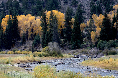
             While I'm savoring the visual feast of golden aspens and elms this week, treat yourself to these scenes of Autumn in the Colorado Rockies.

             Click on any picture to enlarge.

An early September morning—looking south
on Lake City's Silver Street.
Historic cabin in Capitol City, Colorado.  During the silver mining boom
this mountain town, (now practically a ghost town),
had hopes of becoming Colorado's State Capitol.
Aspen-framed peak.
Autumn fishing on the Lake Fork of the Gunnison River.

View of two 14,000 ft. peaks near Lake City.
Uncompaghre is on the right, Wetterhorn is the
tall jagged peak on the left.
Lake San Cristobel near Lake City, Colorado.
To view more autumn photos from the Colorado Rockies, please visit this post:

Tuesday, September 18, 2012

24 hours at Grace Note Farm in Pascoag, Rhode Island


         The Grace Note.  In music it’s a small addition or embellishment, connected to greater things.  In Rhode Island it’s Grace Note Farm—a Bed and Breakfast Inn in Pascoag connected to state forest land and enhancing guest’s experiences in pastoral living.

I visited Grace Note Farm in October of 2011.  Owner Virginia Sindelar met me at the door, then showed me to my room at one end of the sprawling farmhouse while relaying this story:  18 years ago Virginia quit her job as a musician and moved from an oceanfront house in Massachusetts to northwestern Rhode Island in order to “get away from the uncertainty of hurricanes” and start a new hobby: horses.  This 1730 farmhouse and its 94 acres seemed the perfect place to pursue her dreams. Virginia lives here with her mother “Nan”, her dog, several horses, chickens, “Eyeore” the donkey and “Peanut” the pony.  

The bucolic setting of Grace Note Farm in northwestern Rhode Island.

Guests may choose to relax or to indulge in a variety of activities on the farm.  After moving into my suite I met Edna Kent, the local historian who led me on a tour through farm and forest.  We walked the wooded trails in filtered sunlight with American Chestnut trees and Red and White Pines towering overhead.  Edna picked a sprig of soapwood, a plant that always blooms during blueberry season.  After gathering blueberries a person would rub the blooms of sapwood in their hands; the friction caused the blooms to lather, cleansing blueberry stains from the skin.  Nature, in all its elegance.  We continued our tour past an old cranberry bog, hints of fall color appearing in the landscape. 

Old Cranberry Bog on the property.  Autumn's brilliance arrived late
to Rhode Island last year.

Edna and I returned to the farmhouse where Virginia had dinner waiting.  The three of us sat down to a candlelight home-cooked meal of baked chicken with stuffing, garden vegetables, and for dessert—almond cake.  After dinner, while Edna built a fire to warm the great room I met Nan, a delightful lady with a sharp wit.  Nan retired to her room and Edna pulled me aside to tell me that Nan has a birthday coming up on October 23rd.  What’s so special about that?  Well, Nan will be 101 years old!  This is a woman who was buying groceries when I arrived at the farm today.  She helped with dinner and with the dishes.  Tomorrow morning she’ll be feeding the horses and cooking breakfast.  Nan, what’s your secret?

Nan poses after finishing the breakfast dishes.
Her secret to living past 100?  Keep busy and don't think
about aging!

                                                          ****

A stay at Grace Note Farm is a 24 hour affair and Virginia had plenty of activities to fill my second morning and afternoon at the B&B.  In the morning I met horse trainer Leslie Lucas who gave me a 90 minute lesson with “Charlie” a small Morgan.  I’m a novice on horseback but Charlie was a sweetheart; after my lesson I was tempted to make Virginia an offer to buy him.  But I didn’t.

Rita and Charlie.  You can tell he's a great horse just by
looking at him.

Horse barn at Grace Note Farm.  Charlie is peering out
from the far door.
         Nan put lunch on the table—butternut squash soup and apple-walnut salad.  After the nourishing repast I met Virginia’s friend Polly who brought her pony “Popcorn” to the farm to be shoed.  Traveling with Polly was a macaw named “Barkley”, who likes to ride on Popcorn’s back.  Polly demonstrated Barkley’s riding abilities while her little terrier watched from the sidelines.  I asked Polly:  “What’s your little dog’s name?”  “Toto”.  Of course.  Polly is a regular one-woman dog and pony show.

Toto and Barkley wait patiently while Popcorn
is with the farrier.

Barkley mounts his custom saddle and he's
ready to ride.

         My stay at Grace Note Farm ended with a massage given by therapist Lisa Ivens, a perfect end to this incomparable 24 hour get-away.  Interested in experiencing Grace Note Farm for yourself?  Visit this site:  http://gracenotefarmweb.com/