Tuesday, April 26, 2011

Photos from Yosemite

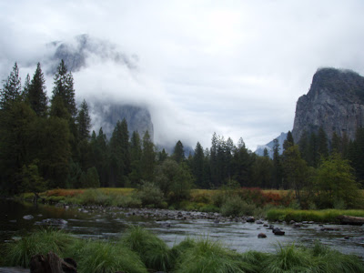
I'm on vacation this week.  Enjoy these pictures from Yosemite.
Click on photo to enlarge.
Climber Camps on El Capitan at Night.
Tanaya Lake


El Capitan in the Fog.

View of Half Dome and Nevada Falls.
Bridalveil Falls

Wednesday, April 20, 2011

California Condor #57 in Zion National Park, Utah

  The California Condor population steadily declined during the 20th century until, in 1987, there were only 22 California condors known to exist in the world.  The last of the free-flying condors were taken into captivity in that year and a captive breeding program was initiated.  Reintroduction into the wild began in early 1992 and continues today.  In 1996 several pairs of breeding condors were released into the wild in Arizona, 30 miles north of Grand Canyon National Park.  Since that time the condors have spread into southern Utah; 70 condors currently soar over the skies of northern Arizona and southern Utah.
*****
Climbing to the top of Angel's Landing.
  It’s a sun-drenched October morning in Zion National Park.  Tim and I catch the shuttle into the park for today’s hike to Angels Landing.  The Angels Landing trail is strenuous and grueling.  The hike is described in the Zion National Guidebook as follows:  “The hike starts along a gradually ascending path by the Virgin River then starts up a series of steepening switchbacks.  There is a small brook through Refrigerator Canyon, a cool, shady mostly level walk under tall Ponderosa Pines.  From Refrigerator Canyon the trail climbs the impressive Walter’s Wiggles, a series of steep and short switchbacks.  After Walter’s Wiggles you reach Scout’s Landing at 2.0 miles, a wide, sandy lookout.  From Scouts Landing the trail makes a final steep 0.5 mile ascent to Angel’s Landing, 1500 feet above the valley floor.  The last half mile requires a 45 minute effort of steep climbing on ridgelines, aided by chains anchored in the rock.  From Angel’s Landing there is a 360˚ view of Zion Canyon.”
  We arrive at trail’s end and, as promised by the guidebook, are treated to a top-of-the-world view.  What could surpass this?  How about the sight of a critically endangered California condor?  Other hikers atop Angel’s Landing point out the huge bird, perched on top of a nearby ponderosa pine.  As we relax and settle down on the rocky outcrop with our lunch the condor takes flight, flapping and soaring above us.  We can see a white tag on his wing identifying him as “Condor 57”.  The magnificent bird completes six circles over Angel’s Landing.  The shadow of his nine-foot wingspan falls on the precipitous rock face before he disappears over the cliffs on the canyon’s western edge. 
Condor 57 Soars over Angel's Landing.
  The hike down from the top of Angel’s Landing to the trailhead is hard on the knees but we’re so exhilarated by our condor experience that we barely notice.  When we return to the visitor center I report the condor sighting to the ranger and he asks me to fill out a form providing details.  Later I look up Condor 57 on the internet and discover that our bird is a male, born in captivity on May 20, 2001 and released in Vermillion Cliffs, Arizona on September 25, 2002. 

  Welcome home, Condor 57.  May you enjoy a long and productive life. 


For more information on California Condor reintroduction go to:  http://www.nps.gov/grca/naturescience/condor-re-introduction.htm

Information on Zion's National Park and the Angel's Landing trail may be found here: http://www.nps.gov/zion/index.htm  and  http://www.zionnational-park.com/zion-angels-landing-trail.htm

Friday, April 15, 2011

Moose Encounter in Rocky Mountain National Park

         Alces alces: The North American Moose 
         These magnificent mammals project the image of goofy, gentle giants.  They are also strict vegetarians, reinforcing their affable appearance.  But a few sinister personality traits lurk beneath the surface of these seemingly benign creatures: moose can be ill-tempered; moose can attack without provocation; moose can kill. 

         Tim and I are camped in Long Draw Campground in Northern Colorado.  This evening we take a drive to the south end of Long Draw Reservoir where Tim will fish a river inside the northern boundary of Rocky Mountain National Park.  We cross a bridge and walk a quarter mile along a gravel pedestrian path by the water.  Tim strings his fly rod and wades into the river while I sit on the path with my book.  After a few minutes I get up to stretch and survey my surroundings.  

         We’re in a stunning setting at 10,175 ft. elevation.  Lofty peaks reach for the sky and surround boggy, willow-filled meadows.  As I scan the river and meadows I say to Tim:  “Looks like there should be a moose in this meadow somewhere.”  
A few seconds later I look up and there he is—a huge bull moose ambling along the path toward us.  A wild animal’s normal inclination is to avoid humans and this moose is still far away, so I alert the moose to our presence by yelling: “Hey Mr. Moose.  It’s us—humans—turn around now!”  The bull keeps coming, eyeing us and lifting his head high into the air.  By ignoring my frantic message our moose declares he has no fear of us—or of anything else.
  After a few more steps in our direction Mr. Moose ducks into the side meadow about 100 yards away.  I’m relieved.  While browsing the willows the moose keeps his eye on us, then moves closer.  I’m worried.  If our bull is having a bad day I have no intention of being a part of it.  Tim and I decide to leave this spot.  We turn around and walk back toward the bridge, then settle down on the other side of a small crest in the path—now we can’t see the moose and he can’t see us.  Tim fishes this section of stream and soon hooks a nice cutthroat trout.  I settle in again with my book, peace restored.  
  Until....  the sound of something crashing through the willows reaches my ears over the din of the water.  I stand up and peak over the hill, looking back to the spot where we had encountered the moose earlier.  The big bull is now running through the meadow directly toward us.  I voice my concern to Tim, pick up my pack, walk briskly to the bridge and cross to the other side of the river.  After crossing the bridge I look back and don’t see the moose.  I do see Tim; he had rushed across the river and scurried up the steep bank on my side.  Tim shouts to me:  “The moose watched me as I climbed out of the water, but then he turned around.  I think he’s gone now.” 
  Tim returns to the river and I pick up my binoculars to scan the hillside.  I no longer see the moose; instead I notice a large herd of elk resting and browsing high on the mountain.  I relax.  
         Until.....  the familiar thrashing and crashing through the willows.  This time Mr. Moose is heading for the river.  He watches me as he eases down the bank and enters the water directly in front of me.  If he crosses the river and starts climbing the bank toward me I’m in trouble.  I look for the nearest tree to climb.  But no—he quenches his thirst with a long drink, then turns around and lopes into the hills.  Another half hour passes; he’s finally gone for the evening.  
  Perhaps Mr. Moose didn’t mean to threaten and frighten us.  Perhaps all he really wanted was a drink—and Tim and I were standing in his way.  We’ll never know.
  Back at the campsite later that night we build a fire and enjoy hot cocoa under the stars, thrilled that our moose encounter ended happily, thrilled that moose still thrive in this part of the world.


Bull Moose Quenching Their Thirst -
photo by Glen Hush for National Geographic.
Interested in a visit to Rocky Mountain National Park?  Look here:
http://rockymountainnationalpark.com/
http://www.nps.gov/romo/index.htm

Thursday, April 14, 2011

Two Hours in Wyoming


  The drive north from Craig to Baggs is a lonely one, the scenery not particularly inviting in April.  During the first few miles snow-covered peaks are visible along the northeast horizon, but they soon disappear from view and rolling sage-covered hills fill the landscape.  Raptors—red-tailed hawks and bald eagles—patrol the sky; these fields contain tasty snacks for birds of prey.  A few marshy areas to the west of the highway host ducks and geese.
 
Wyoming's New State Sign.
40 miles later I come to the Wyoming sign and am happy to see that the state of Wyoming has installed beautiful new signs.  They show a cowboy in front of the Grand Tetons and the slogan on the bottom of the sign proclaims:  “Forever West”.  And I hope that will always be true.  Father Time grinds to a halt in Wyoming.  He throws back his head, inhales deeply, then takes a look around.  What does he see?  Wildlife, fields, meadows, mountains, a land seemingly unchanged from the time of Lewis and Clark’s westward trek.  Yes, there are oil and gas fields, ski towns and tourist meccas.  But it’s the absence of people that stalls the hands of time in Wyoming.  And it’s this lonely place that I’ve come to see.
What is in the town of Baggs?  Not much.  I find a general store, a motel, abandoned homes and run-down businesses.  There is a small cabin—the sign out front informs me that Butch Cassidy had used this cabin as a hideout.  Is there an old cabin remaining in the mountain west where Butch Cassidy did not hide out at one time or another?  I read that there's a "Museum of the Little Snake River Valley" in the town of Savery, 11 miles east of Baggs.  That will be my next destination.  When I get to the town of Savery (population 25) I find the museum at the end of a dirt road.  The museum is closed; the sign out front reads: "Open - Memorial Day, Closed - some cold day in October."  I'll have to come back this summer.


Every town has a Butch Cassidy cabin.


Driving west to Baggs I see a pronghorn buck by the side of the road.  I slow down to take his picture but as my car approaches the antelope he looks up and lopes off.  He stops some distance up the hillside, too far to get a good picture but close enough to appreciate his regal stance, his furtive glance.  I get out of the car and the antelope moves farther away.   A slight breeze rustles the sage in an otherwise silent setting.  It’s what I come to Wyoming for.  There is a kind of nourishment here you can'’t find anywhere else.


The scene between Savery and Dixon.


          Near the town of Dixon an old rancher walks along the road.  Behind him, in front of the barn, sets a tractor loaded with hay.  In front of the tractor a fluffy black Keeshond sits stock still, waiting for his master to open the pasture's gate and deliver hay to the hungry cattle and horses.  I imagine the Keeshond loves to run alongside the tractor, cavorting in the hay and with the livestock.  The rancher nods and gives the “Western Wave” as I pass by.  Entering Baggs I turn south toward Colorado and stop to take a picture of the new Wyoming sign.  

             I continue on, passing a ranch where 12 shiny new shepherd’s trailers stand in a row, ready for sheep season on the high plains.  I stop at a place called Fortification Rocks—a row of rocks protruding from the plains.  The Indians used these rocks as their bastion during battle.  Now they’ve become a "point of interest” along the highway.  While photographing the rocks I hear the calls of ducks in the marshes below the road.  A great sound, waterfowl returning to spring’s thawed out marshes.


Fortification rocks and waterfowl marshes.


Back in Craig I stop at the Serendipity Coffee Shop for lunch—a warm cup of coffee and a pastry nourishing my body as the two hour trip to Wyoming has nourished my soul.
Want to know more?
Check out these links:

Learning From the Elders: A Day in Navajo Country

         Ya at eeh:  Hello; It is good.
  It’s the first Friday of the month and my husband and I are in the small town of Blanding, Utah, evaluating Navajo cataract patients for surgery.  Navajo, or Dine - they call themselves, is the largest tribe of North American Indians.  They live in the Four Corners region of the U.S., having migrated from Northwestern Canada and Alaska over 1,000 years ago.  
Map of Navajo Country.
 
         Our first patient is here, an old Navajo who speaks little English, barely enough to get by.  Tim asks him where he lives and he points east - “Over there”, he says, “by hill and windmill.”  He asks where we live and when I say Price he gestures to the north: “Oh, way over there”, he says.  Isn’t it great, this way of telling and knowing where places are?  The old Navajos were not preoccupied with map-making and measuring everything.  Things are just over here or over there.  
  For the Navajo, language defines culture.  The Navajo language until recently was an unwritten one, their rich traditions and history passed from generation to generation by only the spoken word. It has been said that in Navajo, words paint a picture in your mind. 
  An old woman comes to the office; she speaks no English and brings her daughter to translate.  Anna is dressed in a vibrant multicolored blouse and skirt and she’s adorned with jewelry - turquoise and beads.  
  Anna motions to my necklace - I am wearing a handmade piece recently bought from a young Navajo woman - and then points to her own similar necklace.  Anna is laughing and smiling - the universal language.  As I interact with this woman who speaks to me with her eyes I realize that she represents the end of an era.  Born before interstate highways and mass communication, she is among the very last of the Navajo who have held to their traditions - traditional dress, food and language.  
 
         Yes I know it’s a good thing that their children and grandchildren now have more opportunities to succeed in modern life; of course it is.  But many of the grandchildren speak no Navajo, effectively severing communication with their elders and with their culture.  And these elders represent more than just Navajo culture.  They represent a vanishing way of life, a simple life unencumbered by technology and speed.  We now live in an interconnected world linked through technology, transportation and communication.  These men and women were born before our world came together as one large energy-consuming mass.  They are unique in our homogenous society, in our increasingly homogenous world.  Most people would agree that our inexorable march toward the future is a very good thing indeed.  And yet....  the loss of the old ways of the Navajo, especially language, may eventually result in the disappearance of a people unique to all the earth.  
  I have learned from my Navajo patients today.  I’ve learned to admire their stoicism, their acceptance of the world and their place in it, their ability to project both humility and pride.  Farewell my ama and azhe e (mother and father).

         Hagoonee:  Goodbye; It is settled.
For more information: http://www.navajo.org/history.htm

Tuesday, April 12, 2011

Riding the Trail of the Coeur d'Alenes in Idaho's Panhandle

         The Trail of the Coeur d’Alenes stretches across 72 miles of Idaho’s panhandle. This premier paved rail trail follows the Union Pacific Railroad right-of-way from Mullan, a mountain mining town near the Montana border, to Plummer, a prairie town near the Washington border.

A rest stop on the Trail of the Coeur d'Alenes near Kellogg, Idaho.

        Hawley’s Landing Campground in Heyburn State Park is our base camp for two days of trail riding adventure.  Tim and I awaken before the other campers on this sparkling July morning.  The rail trail beckons; we depart from the campground on our Schwinn tandem bicycle, ready to access the trail at the south end of Lake Coeur d’Alene.

Trail on the railroad bridge
spanning Lake Coeur d'Alene.

          Another few minutes and we’re on the trail which immediately crosses an old railroad bridge spanning the lake.  In the marshes on either side of the bridge are platforms topped with osprey nests.  We stop and enjoy watching the adults and chicks in the nests.  One large nest is perched on the truss above our heads and the adult osprey in residence wastes no time letting us know she’s unhappy with our presence.  She issues a verbal scolding and we decide to continue on and leave mama osprey in peace.  

Osprey nest on bridge abutment.

          This portion of the trail hugs the shoreline of the lake for 8 miles, then follows the Coeur d’Alene River through inland marshes and lakes.  We make our first stop in a pleasant rest area along the river.  We gulp from our water bottles as warblers sing out from the trees.  Leaving the rest stop we pass a field filled with grazing cows, then ride to a marsh and stop to bird watch.  The marsh is full of life today.  Western Grebes are nesting and Common Snipes are feeding.  A turtle suns itself on a log while a bullfrog croaks among the lily pads.  It’s a superb spot for wildlife viewing.

  We stop at another rest area at mile 25.8; while we relax on the bench a group of cyclists ride by and admire our tandem.  It’s time to turn around and head for home.  On the way back to the campground we stop in the small historic town of Harrison.  In 1917 a downtown lumber company caught fire and the blaze consumed about half of Harrison’s business district.  Much of the town was never rebuilt. Today Harrison is enjoying a renaissance as a tourist destination along the Trail of the Coeur d’Alenes; the town is now a popular place for cyclists to stop and/or stay.  Another couple with a bicycle-built-for-two is sitting outside a local bike shop and we stop to chat with them.  They inform us that the states of Idaho, Oregon and Washington host an annual Northwest Tandem Rally.  We’ll have to check it out someday.

  The highlight of our stop in Harrison is a trip to the local creamery where we savor huge ice cream cones—fuel for the final 8 miles of the ride.  During those last eight miles we hear an intriguing call and discover a pair of Red-necked Grebes sailing on Lake Coeur d’Alene.  Listen to the call of the Red-necked grebe here:  http://www.allaboutbirds.org/guide/red-necked_grebe/sounds


The trail of the Coeur d'Alenes provides stunning scenery.
  Before dinner, all cleaned up and with a fresh change of clothes, I stroll around the campground and notice an older couple traveling in a small self-contained RV; a large gray and white tiger cat is leashed to the side of the camper.  I ask the old woman about the cat:  “We’re on the road for most of the year” she said, “We just couldn’t leave Tiger all by himself at home.”  Tiger apparently loves life on the road.  Maybe someday we’ll travel with our cat too... but first we’ll have to find a cat-carrier for our bike at a future Northwest Tandem Rally.

Enjoying an evening by the campfire in Heyburn State Park.

For more information on the Trail of the Coeur d'Alenes travel to these sites:


Check out the town of Harrison on this website: http://www.harrisonidaho.org/

Saturday, April 9, 2011

Tavaputs Ranch Trail Ride

            Head ‘em up, move ‘em out.  It’s time for our trail ride at Tavaputs Ranch in Eastern Utah.  I’m here with my husband Tim, sister-in-law Anne Marie, and niece Amber.  Ranchers Butch and Tate match each of us with a horse, saddle ‘em up and teach us greenhorns the ropes.  
We start through a towering aspen forest under an azure sky.  Tate is in the lead and Butch brings up the rear with his trusty cow horse; three border collies accompany us.  As we dip into the valley Tate points to the left and we turn our heads in time to see a thundering herd of elk, several hundred of them kicking up dust on their way across a distant meadow.  As we re-enter the forest we hear the elk squealing as they charge through the valley below.
Half an hour into the ride we trot down a hill to a stock pond where 125 head of cattle are gathered.  Tate turns to Butch and says:  “These cattle look like they’re ready to move up to pasture on top of the mountain.”  Butch and Tate turn to the four of us:  “How about it?” they ask, “Are you interested in doing some cowboying?”  Are we!
Butch instructs us to whoop it up and holler as he and Tate move the cattle away from the pond.  Tate stays to the left of the herd and Butch and the dogs stay to the right.  Our orders are to ride behind the cows, giving a yip and a yell to let the cows know they’re on a drive.  And so off we go, running cattle across the range.
We run the cattle for 2 miles, cows mooing and calves bawling.  Whenever a cow or calf gets out of line one of the border collies is on its heels, chasing it back to the herd.  It’s fascinating to watch the border collies in action and also to be a part of this cattle drive.  As my sister-in-law said - who could have planned an outing like this in their wildest imagination?  Our niece is having the time of her life and and says she’d love to work, live on or own a ranch someday. 

Riding the Range
When we arrive on the mountaintop Tate opens a gate and we stop to let the cattle know it’s time to slow down and enter their new pasture.  Tate makes a final count of cows and calves and closes the gate behind them.
The horses are ready for quittin’ time.  They know the way home, turn left along a fence line and carry us back to the corral.   Anne Marie and Amber conclude that this is one of the most amazing things they’ve ever done.  I couldn’t agree more.


For more information on Tavaputs Ranch go to:   http://www.tavaputsranch.com/