Sunday, December 30, 2012

Happy New Year from Steamboat Springs, Colorado

When I no longer thrill to the first snow of the season, I'll know I'm growing old.                                                                                                                                 
                                                                                                        ---Lady Bird Johnson

         I'm in agreement with the former first lady on the above sentiment.  Tim and I recently snowshoed our first powder snowfall of the season at Rabbit Ears Pass, southeast of Steamboat Springs, Colorado.

         On the trail we passed two families on a tree-finding expedition—Dad carrying the saw in hand, kids flopping in the snow banks, Mom laughing and snapping pictures.  Later we saw them trekking back to their cars, spruce trees in tow.  It's a family tradition in Routt National Forest country.

        We left the main trail for a lightly used path and found our own little group of Christmas trees with dollops of snow icing on their branches and powdery flakes falling around them.  We took only photos, leaving the evergreens behind for others to enjoy.

 Click below to view a short slideshow (less than one minute) from our first winter frolic:


Sunday, December 16, 2012

Snowshoeing Boulder Mountain, Utah


         Snowshoeing Boulder Mountain in south-central Utah is always a thrill.  Scenic Highway 24 climbs the Boulders, reaches 9600 feet in elevation, and offers numerous plowed pull-outs near the summit.   From there, uphill treks to snow-covered mountain meadows provide views into Capitol Reef National Park and beyond. 

Tim pauses to take in the view of Capitol Reef National Park and the
snow-capped Henry Mountains.

Slightly higher on the mountain (and a year earlier) than the above
photo, Rita is walking in a winter wonderland.

          Boulder Mountain rises to 11000 feet and is the place to find snow, even in years when snowfall totals are lean elsewhere in southern Utah.  Every winter we make an effort to snowshoe the Boulders.  These pictures are some of our favorites from outings over the past four years. 

Surveying my universe through a stand of aspens.

           One year we emerged from an aspen thicket into a clearing to find four trees apart from the grove.  These specimens were enormous—among the biggest, and probably the oldest, aspens I’ve ever seen.  The photos below show the grandeur of the "four ancients". 

Tim stands dwarfed by the four giant aspens.

The old aspen raises its branches into Utah's sunny skies.

         Snowshoeing is a fantastic winter activity that most anyone can enjoy.  Readers, do you have a favorite place to snowshoe?  How about somewhere you've always wanted to snowshoe but never had the chance?  For me, that would be Yosemite National Park.  Maybe someday...

Our day of snowshoeing has come to an end.
Tim glides downhill to our waiting vehicle.

To read about another snowshoeing adventure click here: Snowshoeing in Bryce Canyon National Park

Saturday, December 8, 2012

Climbing Handies Peak in Colorado's San Juan Mountains


          “Because it’s there.”  British climber George Mallory reportedly uttered these famous words when asked why he wanted to climb Mt. Everest.  I have another reason for ascending lofty peaks:  “For the million dollar views.”


View of the Handies Peak area from the trailhead.
The trail passes below the snowfield; Handies Peak is to the left of
the picture.
          Handies Peak is our destination on a blue-sky September day in the San Juan Mountains of southwestern Colorado.  We arrive at the trailhead in the early morning and begin the 2600 foot, two mile ascent.  An hour and 20 minutes later we reach our first break point, Sloan Lake—a blue-green gem nestled into snow-sprinkled peaks.


Tim captures our silhouettes as we pause to
appreciate Sloan Lake.
          A few minutes later we continue on from Sloan Lake, on a near vertical trail heading for the saddle (high pass between two peaks).  Something doesn’t look right; Tim reaches the saddle and is surrounded by knife-edge peaks.  This was not in the trail description.  We slide down the scree-covered slope back to Sloan Lake and find the turn-off for the trail, an unmarked “T” junction on the downslope side of the lake.


Moving on from Sloan Lake.  The Lake is nestled in the depression
on the lower right of the photo.  You can see the trail snaking its way
across the talus on the lower left.
          We make our way across a talus field, then up a series of switchbacks to another saddle.  From there we can see the summit, only a few hundred yards away.  The air is thin and it’s slow-going to the summit but when we reach the 14,048' peak it’s worth every step.  The view from the top encompasses 8000 square miles of San Juan splendor.


I'm ascending the switch-backing trail to the summit.


The view from 14,048 feet.
          For a few precious minutes we have this glorious perch all to ourselves, then we spy two men making their way up the slope to join us on the summit.  The men are from Durango and they’ve climbed Handies Peak today to celebrate the older of the two’s 60th birthday.  The younger man, in his 50’s, has climbed 30 of Colorado’s fifty-three 14ers—peaks higher than 14,000 feet.  
We congratulate the men on their accomplishments, and on their choice of this spot for a 60th birthday get-away, and then we descend.  A day spent on top of the world, reveling in million dollar views?  Priceless.

Speaking of priceless views, in September of 2005 Tim and I hiked to the summit of Uncompahgre Peak.  At 14,321 feet it's the tallest peak in the San Juan Mountains.  Read about it here.  

Read about our attempt to hike another 14er in the San Juan Mountains --  Red Cloud Peak


Read about Handies Peak on the "Colorado Fourteeners Initiative" website:  http://www.14ers.org/peaks/san-juan-mountains/handies-peak/
Discover Colorado's San Juan Mountains by visiting this site:  http://www.americansouthwest.net/colorado/san_juan_mountains/


Thursday, November 29, 2012

Autumn Along the Grand Canyon's North Rim


          North Rim or South Rim?  The choice is yours when visiting Grand Canyon National Park.  Most visitors enter from the south, passing through the gateway town of Tusayan which offers all the amenities—an airport, shops, hotels, even an IMAX theater.  During an autumn visit several years ago Tim and I chose the quieter north entrance and encountered a herd of bison grazing a meadow on the Kaibab Plateau.

        Indoor lodging on the North Rim is limited to the Grand Canyon Lodge—North Rim.  We checked into our Western Cabin, then booked dinner reservations for the lodge’s dining room.   From the lodge we drove along the rim, stopping at two lookout points—Cape Royal and Point Imperial—along the way.  Cape Royal offers a half mile trail to the point.  We walked through stands of pinyon pine, enjoying the canyon views.  The trail passes through Walhalla Ruins, an old settlement of ancient Pueblo Indians.  I wondered:  Did the Pueblos pick this spot for its scenic beauty, or as a strategic place to escape predators and other tribes?  We’ll never know.

View from Cape Royal Point.

At Cape Royal, I'm sitting over an area named "Angel's Window".

         After photographing the canyon we drove through the only full-service campground on the North Rim.  Families were checking in, setting up camp, busying themselves around their campsites, and I was reminded of all the campgrounds I’ve stayed in over the years.  And, unlike most people at the North Rim who are probably thinking “Thank goodness I’m staying in the lodge”, I found myself watching the happy campers and thinking:  “Isn’t this wonderful; how great to be staying and sleeping outdoors on a pristine October day.”  
        Back at our cabin we relaxed and read (Bram Stoker’s “Dracula” for me), and then walked to the main lodge for dinner.   Seated by large picture windows, we watched the setting sun pour its light over millions of years of rock layers in the canyon. We couldn’t have asked for better seats for dinner.  And the food was great too; I enjoyed salmon pasta and Tim feasted on pork with mushroom and green salsa sauce. For dessert, we shared chocolate cake with mint chocolate chip ice cream.


Sunrise on the North Rim.
View into the Grand Canyon from the cabin area of
The Grand Canyon Lodge—North Rim.


          In the morning I woke early to photograph sunrise in the canyon.  Bright Angel Trail, a three minute walk from the cabin, provides unparalleled canyon vistas.  As the sun peaked through the clouds ravens flew overhead, heralding a glorious start to the new day.
        We returned to the lodge for breakfast; I don’t know about you, but for me nothing quite compares with sipping morning coffee and tea on the edge of the Grand Canyon.
        Today’s plan: hiking in the park.  After breakfast we found the Widforss trailhead, named for Gunnar Widforss—an early 20th century artist who lived in and painted the Grand Canyon.  The trail winds for five miles along the canyon rim and through a spruce and fir forest.  At mile 2.5 we heard the piercing cry of a Redtail Hawk and were treated to the sight of two hawks circling overhead.  
        We turned around at that point and decided to hike partway on the Kaibab trail which descends into the canyon.  The Kaibab is the trail into the Grand Canyon—on it you can walk rim-to-rim from the north to the south, or vice versa.  Tim and I only hiked 3/4 of a mile to the Coconcino overlook, a ledge affording sweeping views of the trail down-canyon.  Mule riders, out for a four-hour afternoon trail ride, passed by on their way down.  Looks like fun, but it’s an activity that will have to wait for our next visit.


October is a wonderful time of year to visit The North Rim.


Tree-framed views are common on the Widforss Trail.

Mule riders descend into the canyon on the Kaibab Trail.

         Readers, which would you choose—the hustle and bustle of the South Rim, or the laid-back atmosphere of the North Rim?  Either way, you can’t go wrong with a day spent in Grand Canyon National Park. 

Tuesday, November 20, 2012

More Views from Grand Teton National Park

         National parks have been called America's best idea—places of beauty and history, protected for everyone to enjoy.  Now that's something to be thankful for.  Happy Thanksgiving!


A still pond reflects the majestic mountains.

An old stump frames Teton's snow-capped peaks.

The Old Patriarch tree stands alone in a sagebrush meadow.

Early morning mountain close-up.


Tuesday, November 13, 2012

Wyoming's Watchable Wildlife


        Leaves rustle.  Twigs snap.  Branches sway and bend.  If you’re hiking Grand Teton National Park, these sensory alerts are tip-offs to the presence of wildlife.  

The Greater Yellowstone Ecosystem, which includes the Grand Tetons and surrounding national forests, is home to the greatest diversity of wildlife in the United States.  During a recent trip to the Tetons, Tim and I spotted wildlife in a variety of habitats.  
When one thinks of Wyoming wildlife, large animals such as bison, moose and grizzly bears come to mind.  However, our most cherished wildlife sighting occurred as we walked Swan Lake Trail along Coulter bay.  A golden blur dashed across the trail, then up a tree.  We stopped.  A furry creature peered around the trunk to check us out.  A Pine Marten!  This member of the weasel family is rare and elusive; it prefers old growth forests and wilderness.
        The Pine Marten was trapped to near extinction in the 1800’s; the Hudson Bay Company alone killed 180,000 of these creatures one year, all because of their luxurious pelts.  Their coats are stunningly beautiful, but how nice to see this healthy animal, intact and still wearing its own fur.

The Pine Marten is simply stunning.

         The following photos document the variety of animals we saw over three days in the Tetons.


While walking Taggart Lake Trail we practically stumbled into a deep
hole—a badger hole.  This badger was nearby, waiting for us to leave.


The cow and calf (above) and bull moose (below) are browsing
sagebrush meadows between Jackson Hole and Grand Teton
National Park.


A ground squirrel takes a moment to check us out.
As we drove by this stand of Elderberry bushes
I noticed swaying branches.  Sure enough, this black bear
was stocking up on berries for his long winter's nap.

         If you’re considering a wildlife watching excursion to northwestern Wyoming  grab a copy of Todd Wilkinson’s terrific book “Watching Yellowstone and Grand Teton Wildlife”.  The book describes the habits and habitats of different wildlife species, the best driving routes for wildlife photography, and even offers a wildlife watcher’s code of conduct.

 Autumn wildlife viewing in the Tetons is superb, but winter in Yellowstone provides an even better opportunity to get close to the animals.  See for yourself by clicking here.

Monday, November 5, 2012

Taggart Lake Trail in Grand Teton National Park


         Clouds cap the peaks and a sprinkling of snow clings to the crags and folds of the Grand Teton skyline this morning.  Driving north from Jackson Hole, mountains dominate the view from Moose Junction at the park’s south entrance. 

The snow-cloaked Tetons, sporting their cloud caps.

Our first stop today is the Craig Thomas Visitor and Discovery Center—a $21.6 million, 22,000 square foot facility, opened in 2007.  What an atrocity!  The building is cold, forbidding and impersonal.  It’s U-shaped fortress surrounds a most unwelcoming concrete plaza.   The visitor center’s website proclaims: “...a captivating interior persuades visitors to stay inside”.  Really?  I didn’t want to spend any time inside the cavernous, not captivating, structure; I didn’t want to view the exhibits, I didn’t want to browse the gift shop, I just wanted to get out.   And so that’s what we did.  
          We drive three miles up the road and find the Taggart Lake trailhead parking area; a few other cars are there, as is a group of horses from nearby Gros Ventre ranch, standing by their trailers and waiting to be saddled.  Will they be sharing our trail?

        The trail takes off to the west, the first quarter mile in open country.  The path crosses a cascading waterfall and follows the stream before heading into thick woods.  We last hiked this trail ten years after the 1988 Yellowstone wildfires.  Although those disastrous fires had minimal impact in the Tetons, the last half mile of trail was surrounded by burned trees and parched vegetation.  Today, 14 years after our last visit and 24 years after the fires, many of the dead trees have fallen and the once shrubby young pines have grown 10-12 feet tall.  

Strolling down Taggart Lake Trail on a bright blue October morning.

         We arrive at Taggart Lake and crawl over a pile of tree trunks, scattered like pick-up-sticks on the shoreline.  We gaze at the reflection of 13,000 ft. peaks on the water’s surface, a splendid reward for this short hike.

Logs tossed on the shoreline create an obstacle course to the lake.


Looking for a hand-out, or for shade?  These chipmunks take a break
next to, and under, Tim's hat.


Taggart Lake.

         Our solitude is broken by horses snorting and people laughing.  It’s the group from the ranch, clip-clopping across the bridge spanning the lake’s southern end.  We wave hello to the happy riders as they pass, then begin the return hike to the trailhead.  
         Whether on horseback or on foot, my advice is to skip the Craig Thomas Visitor Center and head directly to Taggart Lake Trail, a worthy destination for day-tripping in Grand Teton National Park.  

                                                           ****

         Journey along with us next week, as we view wildlife in and around the Grand Tetons.


Monday, October 29, 2012

The Hungry Bear: Enter If You Dare!


           This story tells of one of my favorite "Halloween finds".  For those of you who may have missed it last year, enjoy this re-post of my tale from The Hungry Bear Cafe.

                                                           ****

           It’s mesmerizing, this steady beat of the windshield wipers as we travel along rain-slicked Highway 101 on the Olympic Peninsula.  Tim and I are on our way to Rialto Beach in Olympic National Park on a dreary October morning.   
         “We should stop at an espresso stand for hot chocolate on a morning like this.” Tim says, “Espresso stands seem to be everywhere in Washington, there should be one around here somewhere.”  
          The rain continues and we motor west along Highway 101, but no espresso stands appear on this lonely stretch between Port Angeles and Forks.  Near the Rialto Beach turnoff we pass an eating establishment—The Hungry Bear Cafe.  It looks good enough to turn around and go back.  
          Halloween flags decorate the front of the cafe; we enter and find a life-sized Dracula inside the door.   A diminutive, grandmotherly woman behind the counter sweeps her arm:  “Sit wherever you’d like.”

The cafe's benign exterior belies the horrors waiting within.


Whatever you do, don't order the soup!

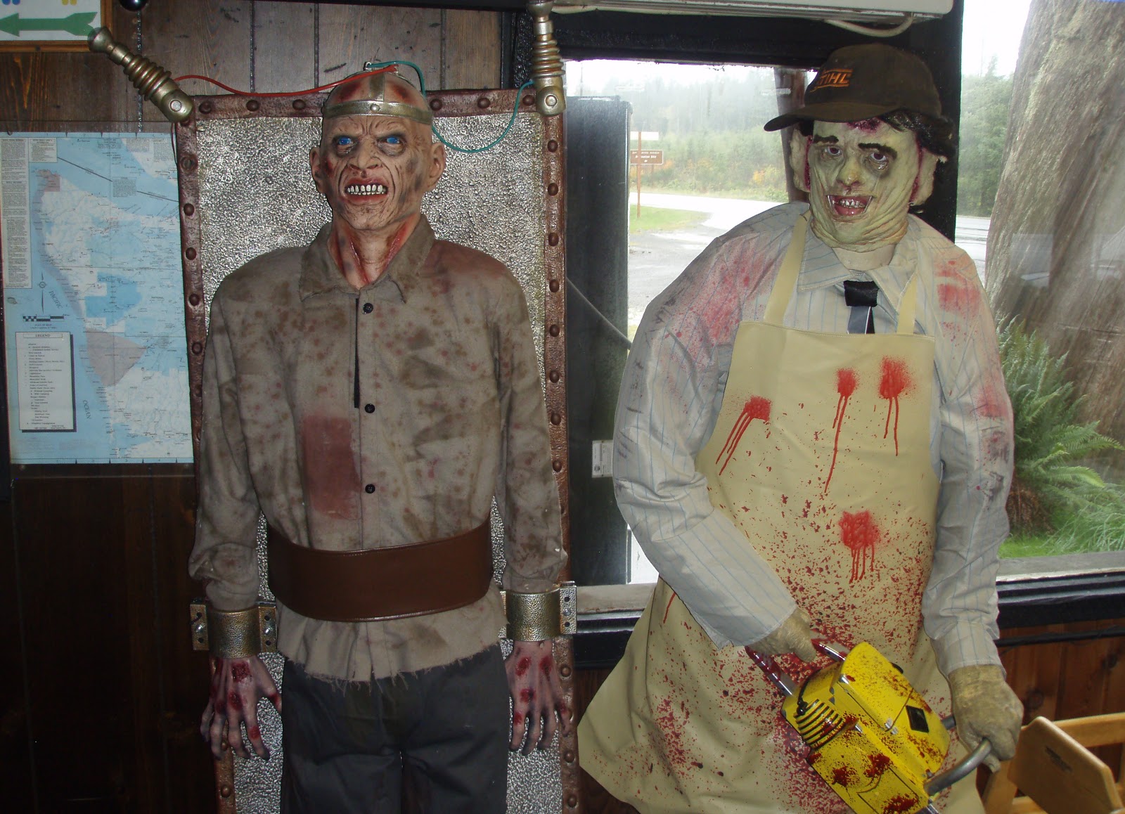
            “Oh, we’re just here for a couple hot chocolates.” I say, as we glance around the empty cafe.  Whoa!  We’re standing inside “Grandma’s House of Horrors”—werewolves, skeletons, witches and monsters lurk in the corners and beside the tables; severed arms hang from the salad bar.
          The Hungry Bear Cafe is full of the scariest Halloween mannequins imaginable.  There’s Dracula, a pumpkin-head monster, a witch hovering over a caldron containing a severed head, a chainsaw massacrer, a man strapped to an electrocution board, a werewolf, and other spooky creatures. 

Frankenstein reaches out for unsuspecting patrons.

I'd think twice about using the restrooms;
these two guard the entrance.

         The cafe’s owner, “Grandma”,  tells us that she and her husband collect the mannequins and her son maintains them.  “We’ve been collecting them for years.  Some of them were quite expensive and several were featured in Hollywood films.”  Grandma steps out from behind the counter and hands us our hot chocolates.  “Go ahead, step on the buttons at the base of the mannequins.”  We do as we’re told.  The mannequins move, talk and shriek; the chainsaw massacre “man” moves and follows us with his life-like eyes.
        This impromptu stop on a misty October day is better than any haunted house. And to top it all off, this creepy cafe’s hot chocolate is delicious. 

"How about a hug?"

"Care for a slice of pumpkin pie?"

"I think I'll look for something toxic on the menu."

         For me, a serendipitous find like The Hungry Bear Cafe is what travel is all about.  Have you discovered a novel eatery on your travels?  

         If you ever find yourself in the Olympic Peninsula, look up the Hungry Bear.  Here’s their website:  http://hungrybearcafemotel.com/

Have a howling good time on Halloween!


Tuesday, October 23, 2012

Laurance S. Rockefeller Preserve in Grand Teton National Park


Warren Buffet or Mark Zuckerberg or Oprah Winfrey or George Lucas or Larry Ellison or Bill Gates or Michael Bloomberg or Paul Allen or Jeff Bezos or Phil Knight or Charles Schwab or the Walton Family....perhaps one or two of them could follow the lead of Laurance S. Rockefeller and peel off a billion or two and buy up some pricey real estate adjacent to a national park or wilderness area, then donate it to the public trust and help fund trails and facilities for the enjoyment of all.  Why not?
                                                                   ----  Bill Schneider, from “Hiking Grand Teton National Park”

An overcast, drizzly day in Grand Teton National Park—what to do?  I consulted our hiking guide and chose the Laurance S. Rockefeller (LSR) Preserve in the southeast corner of the park for the day’s adventure.  


          What makes the Laurance S. Rockefeller Preserve so special?  These 1100 acres within the national park boundaries were owned by the Rockefeller family and used as a dude ranch and private retreat for 70 years.  In 2001 ninety-one year-old Laurance donated the property to the national park service to be returned to its natural state and added to the treasures of Grand Teton National Park.  
Think about it.  Instead of selling off to developers and making tens of millions of dollars, or leaving it to his daughters or son to use for their own exclusive getaways, Mr. Rockefeller donated his ranch to the park system, along with funds for creating a world-class wildlife and natural area preserve.  Thirty ranch buildings, utilities and roads were removed to return the land to a pristine state.  

The LSR preserve contains prime bear habitat.
The aspen trunk on the right shows old bear claw scars.

This black bear was spotted outside the
preserve's entrance.  He's eating his fill of huckleberries
to prepare for his long winter's nap.

          We walked the 2.9 mile loop trail to Phelps Lake; the trail winds through a pine and aspen forest and crosses Lake Creek several times.  Low clouds cloaked the high mountain peaks when we reached the lake, but the calm water, sighing trees, and lack of people made for a striking scene.  

Lake Creek

          The preserve opened in 2008 and today it’s a showcase of impeccable trails and of an astounding variety of plants and animals.  Bear, small animals and birds abound.  Benches on the lakeshore encourage you to sit and stay for awhile—to contemplate the beauty and serenity of the preserve and to thank Mr. Rockefeller for this amazing gift to the American people and to the natural world.  

Tim soaks in the view across Phelps Lake.

Wednesday, October 17, 2012

Day Five: Price to Bryce Bicycle Ride


Thursday, August 30.  Day 5 of the Price to Bryce Bicycle Ride.  Escalante to Bryce Canyon National Park.

Day 5, the final day of our Price to Bryce adventure.  Excited to complete the goal but not eager for the trip to end, we started the day by sleeping in, followed by a late and leisurely breakfast at the Slot Canyons Inn.   
   
While enjoying eggs, sausage, fresh fruit and strong coffee we were “entertained” by stereotypical Ugly Americans—a couple from California who regaled us with tales of their wealth and travels.  Yes, he started a half a billion dollar software company. Yes, they’ve traveled all around the world many times.  Yes, they live in a giant house in Palm Springs with a 500-bottle wine cellar.  Yes, it’s quite a chore picking out a bottle of wine each night for dinner.  Oh my, I feel their pain and... on that note, it's time for us to be moving on. 

                                                             ****


Map, and elevation change graph for Day 5.
Elevation graph:  x-axis starts at zero, each hatch mark equals 10 miles.
y-axis, first hatch mark is 6000 ft., each hatch mark equals 1000 ft.

          We were on our way, only 50 miles from Bryce Canyon National Park, by the time morning clouds burned away to reveal a blue sky. 


          The first summit provided a wonderful place for a short break: a canyon overlook, a rock wall on which to rest, and an outhouse.  What more do you need?


View from rest stop at the 7600' summit between
Escalante and Bryce Canyon.

          Rolling downhill from the summit Tim and Mark passed through the towns of Henrieville and Tropic. Just beyond Tropic peals of thunder rocked the sky as dark storm clouds billowed upon the horizon.  A few miles later I caught up with the bikers as waves of rain and hail washed across the road.  Tim and Mark rushed for refuge in the FJ to wait out the storm.


Entering Henrieville, Tim and Mark encounter an
unexpected road hazard.

Leaving the town of Tropic as storm clouds build.

         Under light drizzle the cyclists started the final steep push to Bryce Canyon’s entrance at 8,000 feet.  Thunder rumbled and lightening flashed but the storm stayed in the distance for the last few miles to the park.


The final uphill climb through drizzly, dreary skies.

We're only a few miles from Bryce Canyon, and
we can see the storm moving away from us.

         As if on cue, clouds parted and sunshine spilled into our little corner of the world as Tim and Mark arrived at the park entrance sign.  There were big smiles, congratulatory hugs, lots of picture-taking. Finally we loaded the bikes on the vehicle and drove to The Best Western Bryce Canyon Inn.


The final few minutes.  Mark and Tim enjoy a relaxing ride
on the entrance road to Bryce Canyon National Park.


We made it!

Mission accomplished!  The driver and the cyclist celebrate
the end of a rewarding journey.

          The celebratory dinner in the National Park’s Bryce Canyon Lodge was marvelous, the best meal of the trip.  I indulged in Maryland-style crab cakes, Tim devoured a rack of ribs and Mark feasted on lobster and flat iron steak.  The evening was perfect, a fitting farewell to an incomparable adventure.


The "hoodoos" of Bryce Canyon.
          Bryce Canyon National Park is beautiful in every season.  Click here to experience the park during winter.

To view the first four days of the Price to Bryce adventure, click on the following links:
Day 1
Day 2
Day 3
Day 4