Friday, December 6, 2019

Joy and Wonder in the Nevada Desert

Our day in Great Basin National Park was not going exactly as planned.
A good news/bad news scenario awaited:


The good news: We woke to a glorious blue-sky framing the mountains above our 
campsite  in Wheeler Peak Campground and, after breakfast and coffee by the campfire, 
drove into the backcountry for sightseeing.


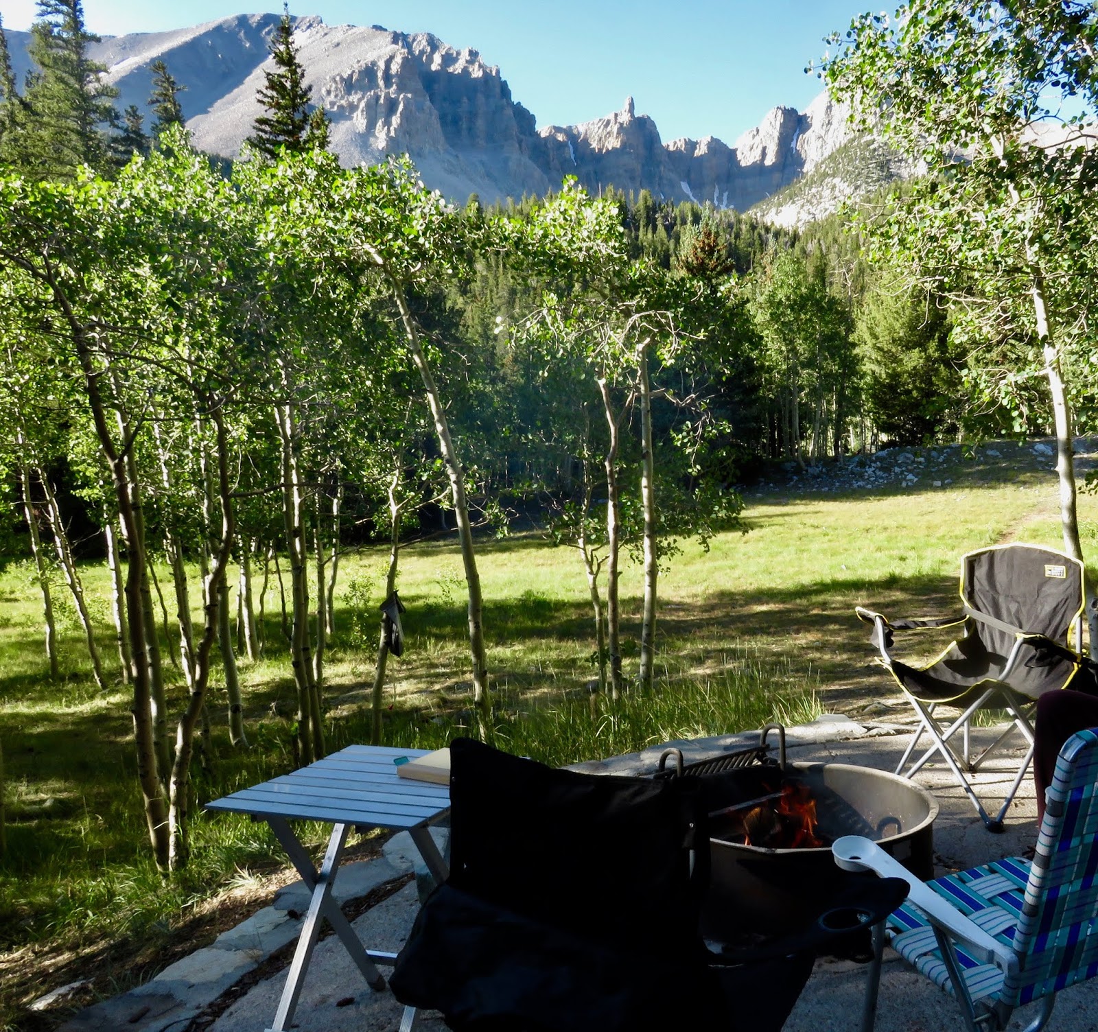
This is why I camp.  You can't beat a morning like this one in Great Basin
National Park.

  The bad news:  My Ford F-150's engine shut off after pulling out from our lunch stop at Baker Creek.  Due to a malfunction in the key's computer chip, the engine no longer recognized the key.  As a result the truck "thought" it was being stolen, and all systems were shut down.
I don't know about you, but I prefer my truck's engine not to do its own thinking.

         The good news:  We had cell service in this remote location, and AAA arranged for a tow truck to pick us up.
       
The bad news:  It would be a five hour wait for the nearest available tow truck to arrive.

The good news:  During the long wait my sisters, nephew and I would have time to hike the Baker Creek Trail, as previously planned.

The bad news:  As we began our hike thunderstorms rolled in, trapping us in the truck for our five hour wait.

The good news:  The tow truck finally arrived and in less than half an hour we were loaded and ready to go.

Lynn's Towing Service—from 150 miles away—to the rescue. 

         The bad news:  The nearest service station was 70 miles away in Ely, Nevada, where we would have to spend the night and have a new key re-programmed in the morning.

         And now… the very good news:   After turning west toward Ely on lonely Highway 50 the tow truck driver and we four weary passengers let out a collective gasp as we came upon this breathtaking scene:

       
A horizon-to-horizon double rainbow!  Our driver stopped the truck and we all jumped out to gape at and to photograph this amazing phenomenon.
(Please click on this photo to enlarge.)
 
         During all my years of outdoor exploration I’ve never been witness to a such a wondrous sight, and likely never will be again.  That evening in the Ely Holiday Inn—far from our campsite in the national park—we four travelers agreed that the day’s travails and misfortunes had all been worth it, for that once-in-a-lifetime experience of joy and wonder in the Nevada desert.

Wishing joy and wonder to all, during this holiday season and beyond!


Saturday, September 21, 2019

The Mystery of the "Old Man" of Crater Lake, Crater Lake National Park, Oregon


         Fifty years ago old Mr. Miller arrived at our community swim club, slipped into the shallow end of the pool, swam a few yards to the deep end and turned over on his back.  He closed his eyes, rested his hands on his belly and floated.  And floated.  And floated some more.

        And so we kids, being kids, did everything in our power to disturb his repose.  We dove in next to him, swam under him, and splashed beside him.  And still old Mr. Miller floated, peaceful and calm as could be.  "Dead Man's Float" we called it.

       An hour later—and still very much alive—old Mr. Miller turned onto his tummy, swam to the shallow end and climbed out.  He toweled off, walked through the gate and drove away, never acknowledging us youngsters and our attempts to rattle him as he drifted about the pool.  How does he do it?, we wondered.

       The Old Man of Crater Lake is also a floating phenom.   And, how does he do it? is a question that has long baffled scientists and observers.   This old man is not human—he's a Hemlock log first spotted in 1886.  He floats upright and traverses Crater Lake from side to side and end to end; every day finds The Old Man in a different spot than the day before.

"The Old Man"
Crater Lake is 6 miles in diameter from east to west and 4.5 miles
from north to south.  The Old Man of Crater Lake has covered more
distance than old Mr. Miller could ever have dreamed.

          Many questions surround The Old Man.  Where did he come from?  Why hasn't he decayed?  Why does he float upright instead of turning on his side as logs are prone to do?  Mysterious indeed.
         At one point scientists wished to remove the Old Man to study him.  But after taking a core sample to determine his age—a miraculous 400 years old—they decided to return him to the lake and leave him in peace.
         The above questions may never be answered and I find that somehow thrilling in this age of instant information.

         Old Mr. Miller is probably long gone; may he rest in peace.  Meanwhile The Old Man of Crater Lake floats on, traversing Crater Lake day-in and day-out as he has done for at least 133 years.   And the enigma of The Old Man of Crater Lake endures.

                                                                         *****

Magnificent Crater Lake.
Our tour group saw the Old Man on a boat trip to Wizard Island.  (Center)

          Have you seen the Old Man?  Crater Lake National Park offers guided boat tours of the lake, staffed by park service volunteers.  You'll learn all about the volcanic eruption which created the lake.  And, if you're lucky, you'll catch a glimpse of the Old Man.

Saturday, June 8, 2019

Congaree National Park, South Carolina


Bottomland Hardwood Forest:  a type of deciduous and evergreen hardwood forest found in US broad lowland floodplains along large rivers and lakes. These forests are occasionally flooded, which builds up the alluvial soils required for the gum, oak and bald cypress trees that typically grow in this type of biome.

         In the mid 19th century 35 million acres of Bottomland Hardwood Forest dominated the landscape from Virginia to Texas.
         But then came the settlers and lumber barons; in five decades virtually all of the old-growth forest was cut down—the lush forests transformed into farms, pastures and cities, and the timber sold for ships, buildings and railroads.
         We humans are remarkably efficient at destroying the natural world to suit our purposes.
       
         Today, less than one percent of Old-growth Floodplain Forest remains; 11,000 acres of it is protected in Congaree National Park in South Carolina.
         Bordered by the Congaree River on its southern edge the park provides the perfect habitat for this lowland forest and, as such, contains the largest remnant of old-growth floodplain forest in the United States.
         Representative trees include Sweetgum, American Beech, Swamp Chestnut Oak, Bald Cypress and Loblolly Pine, with individual trees reaching heights of 150-200 feet.

A Loblolly Pine reaches for the sky along the boardwalk trail.


Bald Cypress Trees.  Notice the small stumps, known as Cypress "knees" alongside the trees.
These "knees" function as both anchors and snorkels for the Cypress.
As anchors they help to stabilize the trees; as snorkels they get air to the submerged roots
when the tree is surrounded by water.  Pretty cool, huh?

         The diversity of plant and animal life in the tiny 26,000 acre park is astonishing; at the same time it's an atrocity that such a tiny remnant of this once-magnificent forest remains.
       
         I didn't know a thing about bottomland hardwood forests until visiting Congaree National Park in May of 2019.
         And I didn't plan to become righteously indignant about the plight of old-growth trees in the south.  Really.  My intention was only to discover a lightly-visited national park I hadn't been to before. 
         But after visiting this little-known gem of a park in South Carolina I can only hope to inspire others to raise their voices to protect old-growth groves—wherever they still exist.


Wednesday, April 3, 2019

Avintaquin Campground in the Ashley National Forest of Southeastern Utah

         For many years I drove by the turn-off for Avintaquin Campground and two questions came to mind:
         What's up with the unusual name?  and,  What's it like to camp there?

         According to the book Native American Place Names of the United States the word Avintaquin is "presumably from Ute, the translation is not clear".   So the answer to the first question is basically an unknown.

         To answer the second question I finally camped at Avintaquin, 15 years after first driving by that US Forest Service sign.  What's it like?  Splendid!
         And I now feel qualified to hazard a guess as to the Ute interpretation of Avintaquin.  How about: "Where the Earth Touches Sun and Stars".
     
        At an elevation of 9000 feet this campground-in-the-sky certainly embodies a heavenly spirit.   The morning sun sets the tree-tops afire and the night sky glitters with starlight.  Situated among towering Douglas Fir trees and quaking Aspens, the sites possess commanding views of rolling valleys and distant mountains.

        Last summer our group of seven women and four dogs spent a dazzling June weekend in the group campsite at Avintaquin.  Nighttime and early morning temperatures dipped below freezing but a blazing campfire provided warmth and good cheer.
        We had such a good time that we reserved the group campsite for the July 4th holiday this year.


The spaciousness of the group campsite was an attractive feature of this campground.
Notice the large "kitchen", far removed from the sleeping quarters.


Temperatures drop in the early evening.
The campfire is ready to go!

Morning sun warms our tent site.
Bring your dogs!
Annie, Lucinda, Jax and Kala (left to right) had as good a time
camping as we women did!

       Avintaquin is not really on the way to anywhere but that's part of its appeal—far from the madding crowds.  If you've had enough of the mob scene in National Parks like Zion and Arches head for our National Forests.  You might discover a hidden gem like Avintaquin Campground.


Friday, February 22, 2019

Rock Art of Nine Mile Canyon, Price, Utah


         It's been called The World's Longest Art Galley.  Nine Mile Canyon cuts through the Book Cliffs Region and West Tavaputs Plateau of Eastern Utah, and the rock art it contains is intriguing and mysterious.

The Great Hunt. 

         My curiosity is piqued when viewing The Great Hunt Panel.  Who carved this?  How long did it take?  Was this done just to pass the time, or to convey information to passers-by?  Is the figure between the sheep at the top of the panel a "god of the hunt"?  Why is the hunter on the right—with bow and arrow—much larger than the hunters to the left and below him?  A Dad and his sons hunting together perhaps?  Why does a figure appear to be walking away from the hunt (lower right), and one of the sheep appear to be falling from the group?
       Part of the mystery of rock art is that we'll never know the answers to these questions.   The Fremont Indians who carved these figures lived in the canyon from 900 to 1200 A.D and then disappeared.
        For one thousand years though, their outdoor artwork has endured.

       Consider the panels below.  In the first one a giant bison-like animal appears alongside smaller animals and a person or two.  In the second one, people and animals are scattered about.  And why is one person lying on his side?  What are the scribblings between the two people and the animal in the center-right of the drawing?  Are some of these chiselings just a type of ancient graffiti?  Or could it be that the Fremont peoples continued to add to these al fresco drawings throughout their tenure in the canyon?  More intrigue, more mystery.

Apparently, large buffalo used to live here.
They were all exterminated by the European settlers.

A lot of incongruous activity is going on in this scene.

           Most people visit Nine Mile Canyon to see The Great Hunt Panel, but there are hundreds of rock art sites scattered along the canyon's 40 mile length.  Why is a 40 mile long canyon named Nine Mile Canyon?  The canyon is named for Nine Mile Creek, which cuts through it.

Picnic area under the shade of Cottonwood trees.

         When visiting Nine Mile Canyon during the spring, summer or fall, bring along a picnic lunch and relax for awhile.  The shaded picnic area provides the perfect spot for pondering the fascinating works within The World's Longest Art Gallery.

Tuesday, January 15, 2019

Feeling the Heat in Death Valley National Park, California


          Furnace Creek Campground on this mid-May morning is all furnace and no creek.

         As the mercury climbs I drag my camp chair into the meager shade of my Toyota Venza, take a sip of coffee, and ponder today’s options.  Where to go when I have only one full day to tour Death Valley National Park?

         A walk from the campground to the adjacent Visitor Center is in order.  I hastily wash the breakfast dishes, then collapse my tent with everything in it and place rocks on top of the whole pile—high winds are forecast for today and I’m not keen to return to camp and find an empty campsite, my tent and its contents scattered across the desert.


My Furnace Creek Campsite.  You can see the frame of my collapsed tent
behind the picnic table.

         At the visitor center I study the park map.  Death Valley N.P. is immense; at 3.4 million acres it’s the largest national park in the lower 48 states.  I formulate a plan to see as many highlights as I can. 
        A bout of lightheadedness and dizziness while in the visitor center—most likely the result of dehydration—convinces me to fill my water bottles and thermoses at the outdoor fountains, and to experience the park’s sprawling grandeur mostly from the comfort of my air-conditioned vehicle.  Today’s high temperature will reach 109°.

        First stop: Badwater Basin, the lowest spot in North America at 282 feet below sea level.  I’ll never stand atop the highest spot on the continent, 19,685 ft. Mt. Denali in Alaska, so might as well plant my feet in the lowest.  And it’s easy to do, as you can drive right up to the parking area, exit your car and walk a few hundred feet to the basin.  Mission accomplished! 


Here it is, the low point of our Western Hemisphere!

         From Badwater Basin I travel the park’s undulating roller coaster roadways, making stops at The Artist’s Palette, Natural Bridge, Mesquite Flats Sand Dunes, and Mesquite Springs.  During short hikes at each stop I guzzle more water and return to the comfort of my car.  I now understand why this is not high visitation season in Death Valley.  One upside: No crowds.


The dunes stretch for two miles and are fun to climb.
Few visitors brave the broiling sand today though.

Along The Artist's Palette scenic drive.

         Back at the campsite winds are raging and I notice a neighboring tent has blown into a clump of trees.  
        At dusk the winds subside and temperatures dip into the 90s.  I re-erect my tent and crawl inside. After gulping a pint of water, I aim a battery-operated fan at my head and drift off to sleep inside my 5’x7’ furnace within Furnace Creek.


Early morning is the time to photograph the shadows of Zabriskie Point.