Tuesday, April 17, 2012

Horse Thief Canyon Trail in Utah's San Rafael Swell


           In the silence we can still hear hoofbeats pounding and see dust clouds swirling from herds of stolen horses thundering their way through this desert canyon.

                                                           ****
          Once a staging area for horse thieves and cattle rustlers, the Old Smith Homestead in Utah's San Rafael Swell is now used to stage a more benign activity—hiking Horse Thief Canyon.  
          The 1880's Smith Cabin is also rumored to have been one of the many hideouts of Butch Cassidy and his gang.  Does a locale exist in the intermountain west that hasn't laid claim to hosting the Wild Bunch during their criminal careers?

Smith Cabin—Home to Nefarious 1800's Activities.
 To view another Butch Cassidy haunt—mentioned in a previous post—click here.

            Unlawful activities far from our minds, two friends and I begin our Horse Thief Canyon hike in a sandy wash through a desert bursting with color.  Cactus and desert wildflowers bloom in reds, oranges, yellows, pinks and purples, their hues complemented by the cream and coral sandstone rock walls surrounding the canyon. 


The brilliant red blooms of the Claret Cup Cactus—considered

one of the desert's most beautiful plants.

Plains Prickly Pear Cactus.

Plains Prickly Pear Cactus plants take root in cryptobiotic soil.

To learn more about the fragile ecosystem of cryptobiotic soil, 
click here.

Orange Globemallow.

Scalloped Phacelia, Scorpionweed.


          We hike for a couple hours and then climb out from the wash to find table-top rocks perfect for a lunch stop.  The setting affords panoramic views of our surroundings—from the Book Cliffs area of eastern Utah to the Henry Mountains of south-central Utah.

          After lunch we turn to retrace our steps and peer across the vast expanse of rock and sky.  Everything looks familiar and nothing does.  With a sense of dread we realize we've lost the trail.  Where did we exit the wash?  We follow a series of rock cairns leading to steep drop-offs over cliff edges.  After more climbing up, over and around groups of rocks we find a cairn we'd seen on the way to our lunch spot. Descending from this cairn delivers us into the correct canyon and back onto our trail.


Rita and Robin begin the return to the trailhead.
But wait?  Where is the route back into the canyon?

Cairns—(a mound of rough stones built as a landmark)
such as these guide hikers across slickrock.

Returning to the trailhead we re-live the tense moments before finding the trail; we've learned a sobering lesson today: It’s easy to become disoriented when hiking the San Rafael Swell and we were ill-prepared to spend the night in the desert.   
Relieved now, we enjoy a little laugh.  After all—if cattle rustlers and Butch Cassidy could navigate and survive in this harsh environment, well, maybe we could have done it too.  
       
                                                            ****
            
           Shade is non-existent on the Horse Thief Canyon Trail so it’s wise to hike this trail on a cool spring day.  The best time of year for wildflower viewing and photography in this area is (typically) the middle of May.  HIking the canyons, washes and slickrock of the San Rafael Swell can be fun—just don’t get lost.
The San Rafael Swell is a remote desert region in southeastern Utah.  You can learn more by visiting these websites:  http://www.sanrafaelswell.org/indexnew.html
http://www.blm.gov/ut/st/en/fo/price/recreation/SanRafaelDesert.html

                                                           ****
            Enjoy these flower photos from a subsequent visit to Horse Thief Canyon:


Hedgehog Cactus.


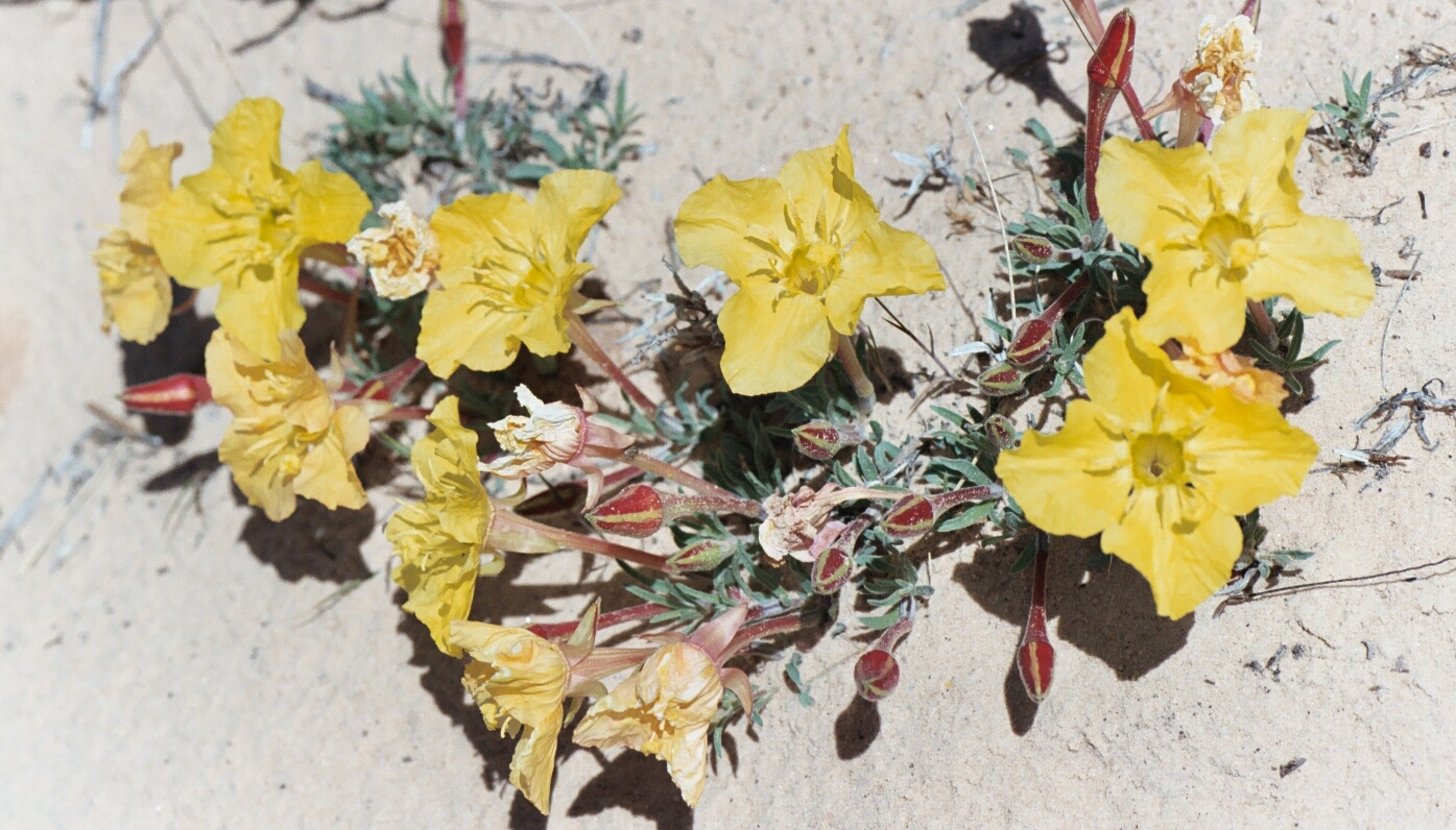
Lavender Evening Primrose—so named because the yellow flowers
fade to shades of orange or lavender upon drying.


Dwarf Evening Primrose.


Yellow Plains Prickly Pear.

Tuesday, April 10, 2012

Golden Throne Trail in the Land of the Sleeping Rainbow (aka Capitol Reef National Park)


          The Indians called it “Land of the Sleeping Rainbow”, this place where ridges of multicolored rock salute the sky.  These slopes, ledges and cliffs created impassable barriers to westward migration for white settlers; they termed the formations “reefs”.  Soaring sandstone domes reminded early explorers of our nation’s capitol dome.  And thus... the “sleeping rainbow” moniker was laid to rest and this land of colorful cliffs and twisting canyons re-christened Capitol Reef National Park. 

Land of the Sleeping Rainbow or Capitol Reef?
You decide.

Tim and I are visiting Capitol Reef for the day trying to decide which trail to hike, and it’s like choosing a topping for your ice cream sundae—no matter what you pick, you know you’re in for a treat.  
The drive to Golden Throne Trailhead is an adventure in itself.  The dirt road, surrounded by desert-varnished walls rising from earth to sky, hugs rocks and dips through washes.
We arrive at the parking area and are surprised by the number of cars.  Capitol Reef, Utah’s least visited national park, has been discovered.  Two trails may be accessed from this point:  Golden Throne and Capitol Gorge.  Golden Throne, our choice for the day, climbs 1100 feet in two miles and leads to a view of the trail’s namesake—a red/orange sheer-faced butte.  


Start here, climb 1100 feet, (a moderate climb)
and leave the crowds behind.

The crowded parking and picnic area for the Capitol Gorge
and Golden Throne trails.

We begin our hike and leave the crowds behind.  Dozens of lizards accompany us on our climb, darting across the trail and scurrying over and under rocks. Our trek transports us around four canyons; scoured over the millennia by rainstorms, these gullies now teem with vegetation and sculpted rocks.   We reach the top with its view of the Golden Throne and relax on the smooth rocks, enjoying the gentle breezes on this radiant day in the land of sleeping rainbows.


A side-blotched lizard scampers onto a rock to
have a look at us.


Indian Paintbrush in bloom along the trail.


Tim hikes toward the Golden Throne.

Rita gazes at the Golden Throne.  I'll bet the Indians
had a better name for this rock too.

View from the top of the trail looking east
toward the Henry Mountains.

An excellent companion guide for day-hiking Utah’s five national parks is 50 Best Short HIkes in Utah’s National Parks by Ron Adkison.

Readers, have you been to any of Utah's five National Parks?

For more information on Capitol Reef National Park, visit this website:  

Links to previous posts about Utah’s parks:

Tuesday, April 3, 2012

Sage Grouse Mating Ritual: View It While There's Still Time


              Pure pageantry in motion—that’s my description for the Sage Grouse’s annual mating ritual, and male grouse provide both the percussion and the costumes for this stunning April spectacle.  As the male struts and inflates his air sacs a low, barely audible “whoomp, whoomp” can be heard, like the slow steady beating on a tom tom.  The bird then flashes his tail feathers, a striking display of yellow-tipped, black and brown plumage. 


Male Sage Grouse about to inflate his air sacs
and serenade us with his drum solo.


Mr. Sage Grouse sports a beautiful white fur collar.

            Early on a spring morning Tim and I joined a Division of Wildlife Resources specialist and several other people in an open sagebrush meadow near Price, Utah.  Through our spotting scopes we observed 20 males and one hen on the lek, or “a patch of ground used by the males for communal display during the breeding season”.  
           The beauty of these grouse and the elegance of the performance unfolding in front of us were mesmerizing.  So much so that for the next several years in mid-April we arose at 5:30 a.m. to spend an hour or two in the presence of these resplendent game birds. 


Males assemble on the lek with hopes of attracting a mate.


Goodbye Mr. Grouse: the yellow tips on his tail feathers are barely visible—
but we could discern them through the spotting scope.

                                                     ****
         100 years ago over 16 million sage grouse could be seen on leks throughout the west.  Today that number is down to 200,000 and dropping rapidly.  Unfortunately for the sage grouse oil and gas production, agriculture, and human habitation is exploding on the low, flat sagebrush meadows the grouse need for reproducing.  It’s likely that the Sage Grouse will not make it through this century.  I consider myself fortunate to have witnessed one of wildlife’s most captivating shows—the sage grouse mating ritual.    
           This grand display may still be observed in remaining scattered sagebrush meadows throughout the intermountain west (see map below).  


Tim looks for sage grouse on a low-lying sagebrush meadow.


Map courtesy: Dr. M. Schroeder, Washington Department of Wildlife.  Taken from US Department of Agriculture (USDA) website.
                                                                                                                                                                      
         For information on Sage Grouse mating areas, contact the state Divisions of Wildlife in the regions shown on the map above.
         Are you interested in helping to protect the Sage Grouse?  Please visit this website:  http://www.voiceforthewild.org/general/sage_grouse_protection.html


Tuesday, March 27, 2012

Wakulla Springs State Park: Home of The Creature from the Black Lagoon


         A prehistoric beast prowls the depths of a remote jungle, preying upon visiting scientists in Hollywood’s Creature From the Black Lagoon.  I’m about to discover the secrets of this primeval forest on a tour of Florida’s Wakulla River, which doubled for The Amazon in the 1954 film.  
The last tour of the day is about to depart when I arrive at Wakulla Springs State Park late in the afternoon.  I hurry to the dock and take my seat on the flat-bottomed boat, along with 10 other tourists.
Our park ranger points to wildlife along the shore as we trawl the river.  Bird life is abundant, including these species: great egrets, blue herons, moorhens, anhingas, wood ducks, black vultures, white ibis, green herons, cormorants, widgeons and hooded mergansers.  The river is also home to reptiles and we spot alligators and turtles sunning themselves on partially submerged logs. 

An Anhinga perches in the dense vegetation along
the riverbank.
 

Reptilian resident of the Wakulla River.

The boat enters a narrow channel where moss drips from tropical vegetation.  Old growth cypress trees—some of them 400-600 years of age—line the riverbanks. Movie scenes were filmed here and the area has an eerie, sinister feel, as if the monster could be lurking nearby.

No, it's not The Creature—a Great Egret
graces the swamp.

The ranger impresses us with these facts on this fun and educational tour:
The Wakulla is fed entirely by a spring 185 feet below the ground which gushes from the earth at the incredible rate of ~400,000 gallons per minute; divers have been exploring the spring beneath the river and have discovered a series of underwater caves 385 feet deep and 4 miles long.  

                                                             ****
After the tour I check into my room in the old Ed Ball Lodge. The lodge was built in 1937 and is definitely showing its age.  Kind of dark and spooky, a la Stephen King’s The Shining, but it should be OK for one night.
In the lobby I discover the genuine—not cinematic—creature from the Black Lagoon, a large alligator specimen with a sad but interesting story:  Affectionately known as “Old Joe” the alligator was of undetermined age (some say he was 300 years old), over 11 feet long and 650 pounds, and he lived on a sand bar in the Wakulla River across from the park’s swimming area.  “Old Joe” never hurt anyone and was considered a part of the family by those who worked in the park.  
Tragically, “Old Joe” was murdered on the night of August 1, 1966;  State Park personnel found his body the next morning, shot between the eyes and floating in the lagoon outside the swimming area.  Presumably he was too heavy to fit into the poacher’s boat.  The Audubon Society and The Wakulla Springs Foundation offered a $5,000 reward for information on his murder but the killer was never found.  Who knows?  Perhaps, in a turn of poetic justice, “Old Joe’s” murderer met his fate at the hands of Hollywood’s mythical swamp beast.
For more information on this fascinating Florida park run, don't walk, to this website:
http://www.floridastateparks.org/wakullasprings/aboutthepark.cfm

The Wild Wakulla River has remained
virtually unchanged for hundreds of years.
                                                                                    ****

              I've just been reminded by a fellow blogger that today is the first anniversary of this blog.  Vickie Bates and I, along with 13 other hopeful bloggers, signed up for a Spring 2011 beginning blogging class with Media Bistro.  As of today, only Vickie and I remain as active bloggers.  Please read her excellent blog:  nobadlanguage.net/


Monday, March 19, 2012

Spring in Utah's Desert: The Corona Arch Hike


          A hike on the Corona Arch trail provides a delightful introduction to the desert’s assorted charms.  The trek begins with an uphill climb; the Colorado River comes into view on the ascent and you may witness rafters drifting along on the gentle current.  Next, a half-mile walk across open terrain showcases desert flora while lizards dart across your path.  Finally, you’ll traverse slickrock while reveling in expansive views of both Bow Tie and Corona arches.  If you’re lucky, when you reach Corona Arch you’ll have it all to yourself—relax, gaze skyward, and reflect in solitude upon this awe-inspiring monolithic span. 
The Corona Arch Trail is everything a desert trail should be—try it and see for yourself.  Find the trailhead by driving north of Moab, turning left on Potash Road and continuing 10 miles to a parking area on the right side of the road.  This hike is best attempted in late March or early April when moderate temperatures and blooming cacti increase its enjoyment.

NOTE:   In the year since this post was written, climbers have figured out how to adapt climbing gear to set up a 250-foot pendulum ride under the arch, transforming this once tranquil place into a thrill-seeking Disneyesque attraction.  Now, while reclining under Corona arch, you may have your solitude broken by adrenaline junkies swinging through the arch.  
Two days ago (March 24, 2013) a climber was killed when he misjudged the length of his rope and crashed into the ground.  I fear this unfortunate incident is likely only to increase interest in this "ultimate thrill ride".

Descriptions of the hike can be found on this website:  http://www.blm.gov/ut/st/en/fo/moab/recreation/hiking_trails/corona_arch_trail.html  

        The following photos detail our progression on this rewarding hike.


A Claret Cup Cactus plant flashes its brilliant red flowers.


The final half mile of the hike presents these panoramic views
 of Bow Tie Arch—left, and Corona Arch—right.


Bow Tie Arch

Rita approaches Corona Arch.

Tim relaxes by the base of Corona Arch.

Rita is dwarfed by this magnificent rock span.
The Oxford American Dictionary defines corona
as "Architecture a part of a cornice having a
broad vertical face".
I think you'll have to agree that not a single man-made
piece of architecture could hope to compete with
this natural corona.

Tuesday, March 13, 2012

Florida's Spring Training Baseball: Then and Now


People ask me what I do in winter when there is no baseball.   This is what I do.  I stare out the window and wait for spring. 
  ---Rogers Hornsby*


          Ah spring, that time of year when a woman’s fancy turns to...baseball?  Yes, it’s true.  I attended my first spring training game in 1984 and have returned to Florida to watch Grapefruit League games four times since then—most recently in 2007.

Flash back to March of 1984:  I’m in Clearwater, Florida to see the Philadelphia Phillies play at old Jack Russell Stadium.  We saunter up to a small booth, buy $8.00 tickets and enter a ball field not unlike that of high school diamonds.  Our bleacher seats are close enough to the action to hear players talking and laughing.  A few rows behind us Phillies announcers Harry Kalas and Richie Ashburn sit in an open-air box; fans walk up to chat with them between innings.
Fast forward to March of 2007:  I’m on the outskirts of Clearwater to watch the Phillies play at brand new Bright House Field.  No more leisurely ticket buying on game days.  Many Phillies spring training games are now sell-outs and tickets may be purchased months in advance for $30.00 to $90.00.  The new venue, while cozy and intimate, has the feel of a minor league ballpark rather than that of a neighborhood town park.  Our seats, though more comfortable than bleachers, aren't close enough to hear players jawing.  Phillies announcers sit enclosed in a broadcast booth high above the field, inaccessible to fans.

Top photo:  I'm posing in front of Jack Russell Stadium in 1984.
Bottom photo: Entrance to the Phillies current spring training facility—

Bright House Field. (Internet photo).


Top photo:  The Phillies play in Jack Russell Stadium in 1984.
Bottom photo:  Pre-game ceremonies at Bright House Field in 2007.


                 Despite the differences during the 23 years from 1984 to 2007, spring training retains its laid-back charm.  It’s still that place where players sign autographs before games and pitchers toss balls to kids standing near the bullpen, still an experience that's worth the trip to Florida for this life-long Phillies fan.
             Florida’s Gulf Coast has seen other changes since the 1980’s:  traffic chokes the roadways, turning a formerly 20 minute jaunt into an hour-long slog; four-lane highways spread across land where orange groves once blossomed; homes and condos replace heron-filled ponds and meadows.  
             And yet... It’s March, and Florida’s 80 degree temperatures, blue skies and palm trees beckon, inviting me to return.  If you’re a baseball fan, go ahead and indulge your springtime fancy—visit this website to find out how:  http://mlb.mlb.com/mlb/tickets/spring_training.jsp

                                                                            
“That's the true harbinger of spring, not crocuses or swallows returning to Capistrano, but the sound of a bat on a ball.”  
                                                     ---Bill Veeck**, 1976

*Rogers Hornsby (1896-1963), considered one of the best hitters of all time, played 23 seasons of Major League Baseball.
**Bill Veeck (1914-1986), longtime owner of the Chicago White Sox, was known for the innovations he brought to Major League Baseball.


Philadelphia's Ryan Howard, 2006 National League's Most Valuable Player,
autographs baseballs for devoted fans.  My nephew Mark—on left—is next in line.

Wonderful McKechnie Field in Bradenton—home of the Pittsburgh Pirates.
You can still catch a game here for $20.00
My nephews Paul and Bob are standing at the base of the palm tree.


"Two All Stars"
Phillies All-Star (and all-around good guy) Jimmy Rollins
poses with my nephew Bob (an all-around good guy too!).


View from Al Lang Field in St. Petersburg, former spring training home
of the Tampa Bay Rays.
In 2009 the Ray moved to Charlotte Sports Park in Port Charlotte.

Wednesday, March 7, 2012

Bryce Canyon's Clear Air—Threatened


         Would you like to travel to Bryce Canyon National Park and see those impossibly blue skies—featured in last week’s post—for yourself?  If so, you had better visit soon because Bryce’s azure skies are threatened by a proposed expansion to the Alton Coal Mine, a mere 10 miles from the park.  
Currently the mine operates on 635 acres of private land but mine owners are seeking permission from the Bureau of Land Management (BLM) to expand their operation to 3500 acres of public land—land owned by you and me.  Alton Coal is the only strip mine in Utah; consequences to the area will be increased air pollution, noise and truck traffic, all of which will negatively impact Bryce Canyon’s transcendent views and serenity.  

Bryce Canyon's clear skies, as well as area wildlife, are threatened
by a proposed coal mine expansion.

I know the facts: coal generates over 50% of our nation’s electricity and we’re all using more and more of it (that goes for those of us sitting at our computers). And yes, all that coal has to come from somewhere—but I hope you’ll agree with me that the BLM should proceed with caution before approving a large strip mine on the boundaries of an incomparably beautiful national park.
Read more reactions to Alton Coal’s proposed mine expansion on these websites:   http://www.sltrib.com/sltrib/politics/53434361-90/alton-blm-comments-county.html.csp#.T1Kmr0N_Vaw.email
Find out how you can register your disapproval by visiting this website:  http://www.haltaltoncoal.com/
The National Park Service Retirees is a group of individuals working to ensure that the national parks stay true to their mission of protecting resources for future generations of Americans.  This is a worthwhile goal from a respectable organization.  Visit their website:   http://www.npsretirees.org/