Tuesday, October 23, 2012

Laurance S. Rockefeller Preserve in Grand Teton National Park


Warren Buffet or Mark Zuckerberg or Oprah Winfrey or George Lucas or Larry Ellison or Bill Gates or Michael Bloomberg or Paul Allen or Jeff Bezos or Phil Knight or Charles Schwab or the Walton Family....perhaps one or two of them could follow the lead of Laurance S. Rockefeller and peel off a billion or two and buy up some pricey real estate adjacent to a national park or wilderness area, then donate it to the public trust and help fund trails and facilities for the enjoyment of all.  Why not?
                                                                   ----  Bill Schneider, from “Hiking Grand Teton National Park”

An overcast, drizzly day in Grand Teton National Park—what to do?  I consulted our hiking guide and chose the Laurance S. Rockefeller (LSR) Preserve in the southeast corner of the park for the day’s adventure.  


          What makes the Laurance S. Rockefeller Preserve so special?  These 1100 acres within the national park boundaries were owned by the Rockefeller family and used as a dude ranch and private retreat for 70 years.  In 2001 ninety-one year-old Laurance donated the property to the national park service to be returned to its natural state and added to the treasures of Grand Teton National Park.  
Think about it.  Instead of selling off to developers and making tens of millions of dollars, or leaving it to his daughters or son to use for their own exclusive getaways, Mr. Rockefeller donated his ranch to the park system, along with funds for creating a world-class wildlife and natural area preserve.  Thirty ranch buildings, utilities and roads were removed to return the land to a pristine state.  
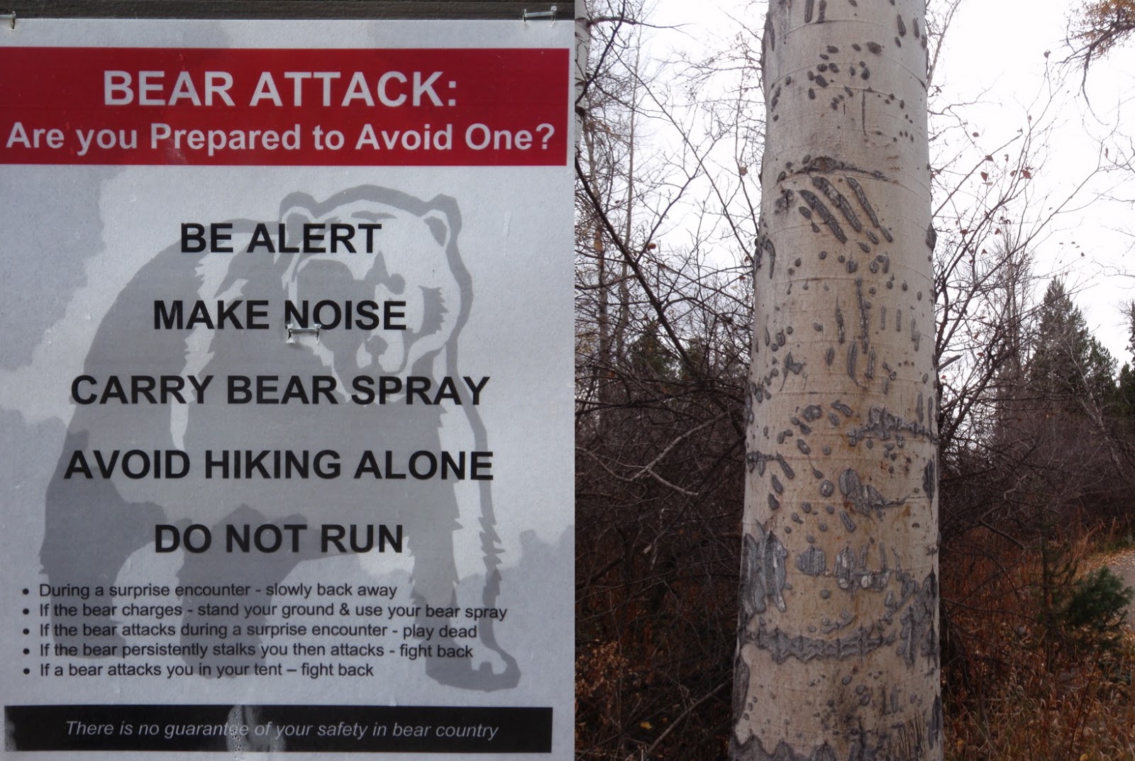
The LSR preserve contains prime bear habitat.
The aspen trunk on the right shows old bear claw scars.

This black bear was spotted outside the
preserve's entrance.  He's eating his fill of huckleberries
to prepare for his long winter's nap.

          We walked the 2.9 mile loop trail to Phelps Lake; the trail winds through a pine and aspen forest and crosses Lake Creek several times.  Low clouds cloaked the high mountain peaks when we reached the lake, but the calm water, sighing trees, and lack of people made for a striking scene.  

Lake Creek

          The preserve opened in 2008 and today it’s a showcase of impeccable trails and of an astounding variety of plants and animals.  Bear, small animals and birds abound.  Benches on the lakeshore encourage you to sit and stay for awhile—to contemplate the beauty and serenity of the preserve and to thank Mr. Rockefeller for this amazing gift to the American people and to the natural world.  

Tim soaks in the view across Phelps Lake.

Wednesday, October 17, 2012

Day Five: Price to Bryce Bicycle Ride


Thursday, August 30.  Day 5 of the Price to Bryce Bicycle Ride.  Escalante to Bryce Canyon National Park.

Day 5, the final day of our Price to Bryce adventure.  Excited to complete the goal but not eager for the trip to end, we started the day by sleeping in, followed by a late and leisurely breakfast at the Slot Canyons Inn.   
   
While enjoying eggs, sausage, fresh fruit and strong coffee we were “entertained” by stereotypical Ugly Americans—a couple from California who regaled us with tales of their wealth and travels.  Yes, he started a half a billion dollar software company. Yes, they’ve traveled all around the world many times.  Yes, they live in a giant house in Palm Springs with a 500-bottle wine cellar.  Yes, it’s quite a chore picking out a bottle of wine each night for dinner.  Oh my, I feel their pain and... on that note, it's time for us to be moving on. 

                                                             ****


Map, and elevation change graph for Day 5.
Elevation graph:  x-axis starts at zero, each hatch mark equals 10 miles.
y-axis, first hatch mark is 6000 ft., each hatch mark equals 1000 ft.

          We were on our way, only 50 miles from Bryce Canyon National Park, by the time morning clouds burned away to reveal a blue sky. 


          The first summit provided a wonderful place for a short break: a canyon overlook, a rock wall on which to rest, and an outhouse.  What more do you need?


View from rest stop at the 7600' summit between
Escalante and Bryce Canyon.

          Rolling downhill from the summit Tim and Mark passed through the towns of Henrieville and Tropic. Just beyond Tropic peals of thunder rocked the sky as dark storm clouds billowed upon the horizon.  A few miles later I caught up with the bikers as waves of rain and hail washed across the road.  Tim and Mark rushed for refuge in the FJ to wait out the storm.


Entering Henrieville, Tim and Mark encounter an
unexpected road hazard.

Leaving the town of Tropic as storm clouds build.

         Under light drizzle the cyclists started the final steep push to Bryce Canyon’s entrance at 8,000 feet.  Thunder rumbled and lightening flashed but the storm stayed in the distance for the last few miles to the park.


The final uphill climb through drizzly, dreary skies.

We're only a few miles from Bryce Canyon, and
we can see the storm moving away from us.

         As if on cue, clouds parted and sunshine spilled into our little corner of the world as Tim and Mark arrived at the park entrance sign.  There were big smiles, congratulatory hugs, lots of picture-taking. Finally we loaded the bikes on the vehicle and drove to The Best Western Bryce Canyon Inn.


The final few minutes.  Mark and Tim enjoy a relaxing ride
on the entrance road to Bryce Canyon National Park.


We made it!

Mission accomplished!  The driver and the cyclist celebrate
the end of a rewarding journey.

          The celebratory dinner in the National Park’s Bryce Canyon Lodge was marvelous, the best meal of the trip.  I indulged in Maryland-style crab cakes, Tim devoured a rack of ribs and Mark feasted on lobster and flat iron steak.  The evening was perfect, a fitting farewell to an incomparable adventure.


The "hoodoos" of Bryce Canyon.
          Bryce Canyon National Park is beautiful in every season.  Click here to experience the park during winter.

To view the first four days of the Price to Bryce adventure, click on the following links:
Day 1
Day 2
Day 3
Day 4


Saturday, October 13, 2012

Day Four: Price to Bryce Bicycle Ride


Wednesday, August 29, 2012.  Day 4, Price to Bryce Bicycle Ride: Boulder to Escalante.


Map and Elevation Change graph for Day 4.
x-axis: starts at zero miles, each hatch mark equals 10 miles.
y-axis: starts at 5000 ft. each hatch mark equals 500 ft.

         Early morning's low light and cool temperatures accompanied the cyclists as they left Boulder at 7:30 a.m.  Today’s short ride included a series of ups and downs along Utah Highway 12, a designated Scenic Byway through the canyon country of Grand Staircase Escalante National Monument. 


Undulating Highway 12 winds its way through the Monument.

Tim overlooks the canyon containing Upper and Lower Calf Creek
Falls and Calf Creek Recreation Area.

          Calf Creek Recreation Area is the main attraction along this stretch of highway.  The six-mile round-trip hike to Lower Calf Creek Falls and the four mile round-trip hike to Upper Calf Creek Falls provide excellent examples of the geologic and scenic wonders of this region.  Tim and I have hiked both trails in the past; however we didn’t take the time for this side trip today.  


Along the Lower Calf Creek Falls trail.
Upper Calf Creek Falls.

Lower Calf Creek Falls.


          Leaving Calf Creek the road climbs through multi-colored sandstone formations, then descends through ranchland to the town of Escalante.  Tim and Mark rolled into town by 11:00 a.m. and we found our luxury B&B, the Slot Canyons Inn, 5 miles west of there.  We arrived too early for check-in—what to do instead?   We decided on a trip to Peek-A-Boo and Spooky slot canyons in the National Monument.  These two slot canyons, although non-technical, are full of challenging climbs and narrow passageways.  Click here to read my report about our day of action and adventure in the slots.


The arrow is pointing to Tim as he climbs a hill between Calf Creek
and Escalante.  If you can't see the bright jersey, click on the photo
to enlarge.
This photo illustrates why Highway 12 was
designated a National Scenic Byway.

Tim and Mark, rolling into the town of Escalante.

            After our adventures in the slot canyons we returned to the appropriately named Slot Canyons Inn and savored meals of local grass-fed beef while dining alfresco at The North Creek Grill, on-site at the B&B.  Everyone agreed—this was our favorite day of the journey so far!


This piece of tile work graces the
front wall of the Slot Canyons Inn.
To view the other four days of the Price to Bryce bicycle adventure, click on the following links:

Wednesday, October 10, 2012

Day Three: Price to Bryce Bicycle Ride


Tuesday, August 28, 2012.  Day 3 of the Price to Bryce bicycle ride.  Teasdale to Boulder.

          The map below shows the route from Teasdale to Bryce Canyon.  Much of the final three days of riding took place within and around the 1.9 million acre Grand Staircase Escalante National Monument, a geologic wonder and outdoor enthusiast's playground.


Map, and elevation change graph for Day 3.
Elevation graph:  x-axis starts at 0 miles.  Each hatch mark equals 10 miles.
y-axis starts at 7000 ft., each hatch mark equals 1000 ft.

          A grueling climb over the 9600 ft. summit of the Boulder Mountains was the highlight of today’s ride.  The weather was perfect for a mountain ride—early morning temperatures in the 40's had warmed up to 70 degrees by midday.  Tim and Mark cruised into Boulder by 2:00 p.m., giving us plenty of time to check in to the Boulder Mountain Lodge and take a drive on the Burr Trail Scenic Byway in Grand Staircase Escalante National Monument.


Climbing the mountain, Tim approaches our FJ Cruiser,
the ultimate SAG (support and gear) wagon.
Tim at the summit.  This was the high point of the
235 mile ride.  Tim reported no ill effects from the altitude!

View from the summit of Boulder Mountain, looking east into
Capitol Reef National Park and to the Henry Mountains.


Cruising down the mountain and into the town of Boulder.

Day three's welcome destination, Boulder Mountain Lodge.

         With the bikes secured to posts outside our rooms the three of us hopped in the car and drove into the National Monument.  Our destination was an unnamed slot canyon, 22 miles from the lodge.  Following directions handed to us by the receptionist at check-in we found the small parking area on the side of the road and walked the dusty trail to the hidden slot.  Towering walls closed in around us; we looked up to spy just a sliver of blue sky several hundred feet above our heads. 


Under the cottonwoods at the entrance to the
hidden slot canyon.

Inside the slot:  a sliver of sunlight
reaches into this amazing "secret" canyon.
Sandstone formations such as these make the Grand
Staircase Escalante National Monument a geologist's dream.

          We returned to Boulder Mountain Lodge for dinner at Hell's Backbone Grill.  The restaurant serves organic and home-grown food; fruits and vegetable are harvested from their own organic farm.  After dining on blue corn encrusted trout and grilled pork tenderloin we gathered on the lodge's back porch overlooking a small pond.  We listened to the evening calls of ducks and geese and watched bats swoop to and fro in the twilight—a fitting end to another day of adventure. 

To view the other four days of the Price to Bryce adventure, click on the links below:
Day 1
Day 2
Day 4
Day 5

Saturday, October 6, 2012

Day Two: Price to Bryce Bicycle Ride


            Monday, August 27, 2012.  Day 2 of the Price to Bryce bicycle ride.  


Map (top) and Elevation change graph for Day 2.
Graph:  x-axis starts at zero, each hatch mark equals 10 miles.
y-axis starts at 6000 ft. elevation, each hatch mark equals 1000 ft.

          Today’s trek began with a car ride to Interstate 70, the endpoint of yesterday’s ride.  I dropped Tim and Mark off at the underpass and they started the ride along Highway 72, over the mountain pass in Fishlake National Forest, then southwest to the town of Teasdale, Utah—a small, mostly residential town just minutes from the town of Torrey and the entrance to Capitol Reef National Park.


Tim and Mark begin the second day's ride under threatening skies.


Tim climbs the switchbacks to the summit.


Mark takes a break at the summit, overlooking Cathedral Valley
in Capitol Reef National Park.


Tim is on his way down from the summit.  You can find
him by looking for the little green dot just to the right of center
in this picture.  (Or, click on photo to enlarge.)

         The cyclists encountered cooler temperatures, rain and thunder during the ride, but by late afternoon the sun shone on their endeavors.  We all pulled into the Muley Twist Inn shortly before dinner and were shown to our upstairs rooms.


A showery lunch break at Forsythe Reservoir in Fishlake NF.


Highway 72 snakes behind Mark as he and Tim
pedal away from Forsythe Reservoir.

Considering exchanging their rides for something with
more horsepower?

Sunshine for the final section of the ride between the towns
of Bicknell and Teasdale.

           We checked into our rooms and, after showering, Tim started the daily routine of washing bike clothes and headbands, then rinsing and refilling water bottles and thermoses for the next day’s ride.  We had dinner at The Rim Rock Restaurant, enjoying our meals of blue-cheese burgers and homemade fries while gazing through floor-to-ceiling windows into Capitol Reef National Park and the Boulder Mountains.
          Later that evening we convened on the long porch of the Muley Twist Inn to watch the setting sun cast its shadows over red rock country.


A great way to end the day:  views into Utah's color country
from the front porch of the Muley Twist Inn.


Panorama Point in Capitol Reef National Park.
To view the other four days of the Price to Bryce bicycling adventure, click on the links below:

Wednesday, October 3, 2012

Day One: Price to Bryce Bicycle Ride


The 235 mile trip between Price, Utah and Bryce Canyon National Park traverses two National Forests, one National Monument, mountain passes, deserts and canyons.  The drive can be completed by car in four to five hours.  To transform this excursion from a 65 mph express ride into an unhurried expedition my husband Tim crafted a plan:  how about a five-day bicycle trek—carving the distance into manageable chunks, eating in fine dining establishments, and lodging in comfort every night?  Sounds like fun.
And so, in January of 2012 Tim started training for the first annual(?) Price to Bryce bicycle ride.  By August he was ready to go.  Tim’s friend Mark flew from New York to accompany him on the ride and I drove the support vehicle, stocked with water and energy drinks, rain jackets and spare tires.

The map below shows the total route and elevation changes for the journey.

Elevation change per mile graph—X-axis:  starts at 0 miles, each hatch mark equals 100 miles.
Y-axis: starts at 5000 ft. elevation, each hatch mark equals 1000 ft.


          Day 1:  Sunday, August 26.  From Price, south on Highway 10 to Interstate 70.  This 70 mile stretch rolls through Utah’s Castle Country, known for high desert sagebrush meadows and red-rock mesas and buttes.


Map (top) and elevation change per mile graph (bottom) for day 1.
Elevation change per mile graph— X-axis: starts at 0 miles, each hatch mark equals 10 miles.
Y-axis: starts at 5000 ft., each hatch mark equals 1000  ft. 


           Tim and Mark completed the ride in 6 hours.  Scenes from Day One can be found below.   


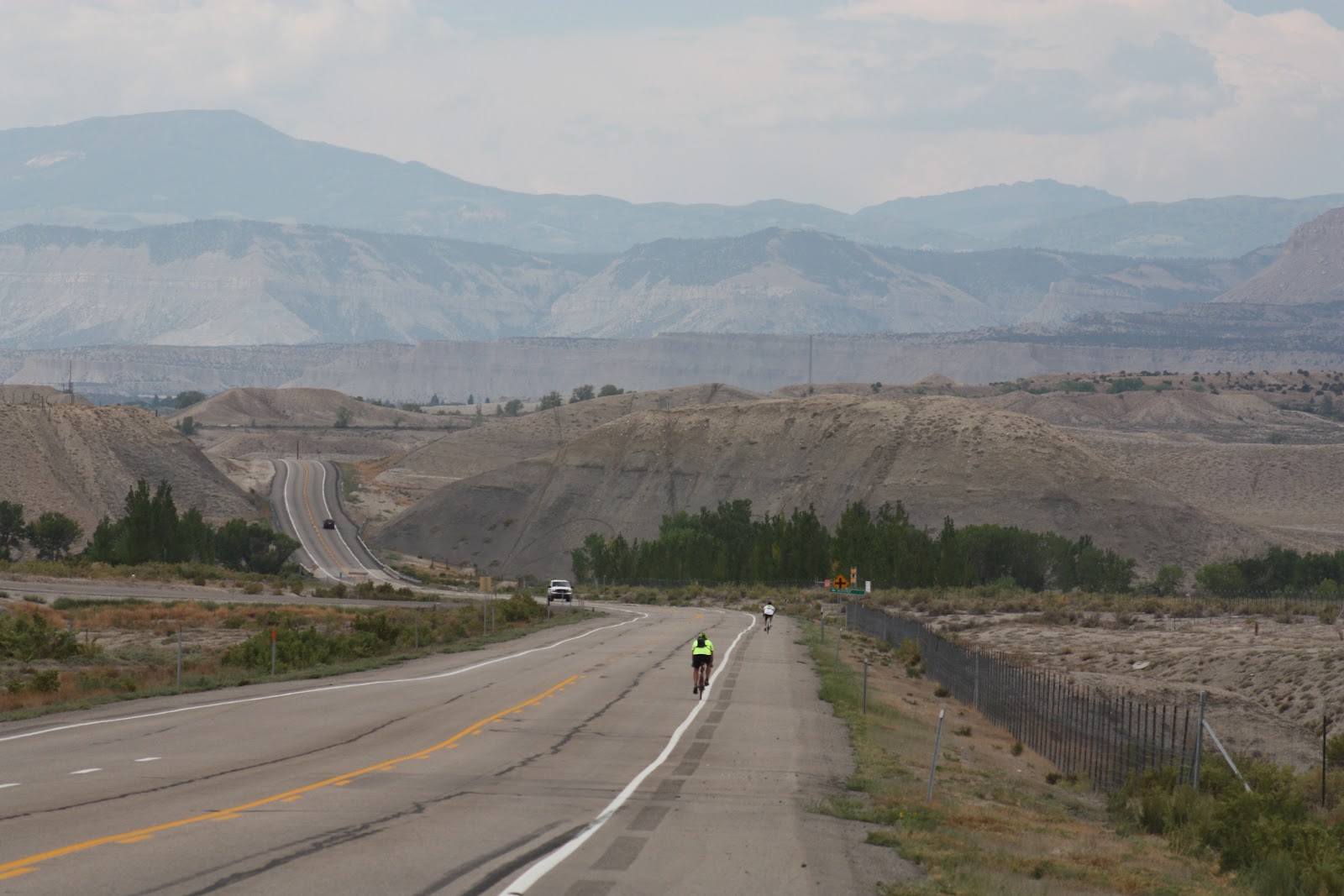
Tim (front) and Mark begin their ride south on Highway 10
in Central Utah.


Mark and Tim pose in Emery County, Utah.
Our new puppy, "Annie" (resting behind Mark) rode in the support vehicle with me.


With apologies to Montana, Utah's Castle Country
boasts Big Sky views too.


Tim rides under the I-70 overpass—
Day One's destination—none the worse for wear.

            Interstate 70 intersects Highway 10 in a remote and desolate region of Utah—no restaurants or lodging to be found—so I picked up Tim, Mark and the bikes and returned them to Price for a dinner of Greek meatballs and sauce, Greek salad, homemade wheat bread and baklava, cooked and generously provided by our neighbors Deano and Shelley.  Thanks guys!

                                                            ****

This is the first in a five part series, detailing the highlights of the Price to Bryce trek each day.  Stay tuned for part two...

To view the next four days of this adventure, click on the links below:
Day 2
Day 3
Day 4
Day 5