Tuesday, October 4, 2016

Nevada Beyond the Neon: Santa Rosa Mountain Range in the Humboldt National Forest


There's gold in them thar hills.
          Arrowleaf Balsamroot is the common name of the wildflowers shown above.  The flowers are named for the shape of their leaves and the fragrant balsam in their roots.  Fair enough.
          I can't help but imagine though, that the bands of Northern Paiute who inhabited this area years ago ascribed more inspirational names to these carpets of gold—"Fields of Sunshine" perhaps, or "Sunrise Touching the Hills".

          These first manifestations of spring ambushed our senses as we climbed Hinkey Summit Road in the Santa Rosa Range of the Humboldt National Forest in north-central Nevada.
       
          Our two-day trip to the Santa Rosa Range included other sensuous pleasures as well.   Driving past a spindly half-dead tree on the hillside we noticed a nest cradled in its branches.  After stopping the truck to inspect this find we spied two fuzzy heads bobbing in the nest.  And then we heard it, that tell-tale piercing scream—you've probably heard it on the soundtrack of a western movie or television show—of a Red-tailed Hawk.  Red-tail chicks!  I had never seen them in the wild and so Tim and I tentatively crept up the hill toward the tree.
         The screech we heard earlier meant that mama hawk was nearby and sure enough she flew into the nest, gave her chicks a scolding for allowing themselves to be seen, and then dive-bombed the two of us.  Warning taken.  We scrambled down the hill and away from those razor-sharp claws.  And the chicks didn't surface again.  Those youngsters listen to "Mom" when she tells them to lie low.

Red-tail Hawk family.  On our return down the mountain we saw the entire
family in the nest.  This time, using the truck as a blind,
Tim took this zoomed photo.
Mama and Papa hawk didn't pay any attention to us—so long
as we stayed by our truck.
         Singas Creek Trail presented another perspective on this mountain range.  The steep trail on the east side of the Santa Rosas climbs through wildflower-strewn alpine meadows and past mature aspens on its way to lichen-covered granite spires.  Tim and I had the trail to ourselves on this June day.
         Solitude and scenery.  Can't beat it.

Brilliantly colored lichen adorns the granite in the Santa Rosa Range.

          Our final visual treat was the town of Paradise Valley, a virtual ghost town now inhabited by 109 souls.  The town was named "Paradise" after an early settler exclaimed: "What a paradise!" upon viewing the mountains to the west.  With its abandoned buildings, rusty vehicles and towering old cottonwood trees the town these days would be better-suited as the setting for an episode of The Twilight Zone.

Paradise?  Or the scene of a horror show?  You decide.

          As with most everywhere in rural Nevada the town of Paradise Valley and the remote Santa Rosa range are accessed by one lonely dirt road.  If you choose to experience the treasures of north-central Nevada, mid-June is the perfect time to view its fields of sunshine and fledgling birds of prey.

Thursday, September 22, 2016

Nevada Beyond the Neon: Onion Valley and Knotts Valley Reservoirs

         Take the Crayola challenge!

         Inspect the photo below to find the colors in a 16 count box of crayons*.

The road and the views stretch to the far horizon.
Click to enlarge.

          Most reservoirs in the western United States are as drab and uninspiring as they’re defined:  “...  large lakes used as a source of water supply.”  But not these two.  Located in remote northwestern Nevada, Onion Valley and Knotts Valley require a commitment of time and effort to access but are well worth the endeavor.  And the scene above, along the eight mile drive between the two reservoirs, should put to rest any descriptions of the Nevada landscape as monochromatic.


This is the long and winding road from the tiny town
of Denio Junction, NV to Onion Valley Reservoir.

         The reservoirs offer fishing and camping and our campsite high above Onion Valley Reservoir ranks as my favorite campsite of all time.

Our campsite (above and below) at Onion Valley Reservoir.
The view above is looking toward the lake.  Turning around, below, provided
 this view across northwestern Nevada—and into Oregon as well.

The world at our feet.


Tim fishes Onion Valley and is rewarded with a large rainbow trout.

         If you’re traveling Interstate 80 across Nevada and wish to escape the monotony of the four-lane, venture far from the beaten path to visit these two polychromatic reservoirs.  I guarantee you'll never again accept the definition of them as mere "water supply sources". 


Knotts Valley Reservoir.  Tim is the tiny dot in the float tube—
far right and center of photo.


Wild Irises bordered Knotts Valley reservoir on the June day
we visited.


* How did you do on the Crayola challenge?  Scrutinizing the photo I identified fourteen of the sixteen hues: orange, yellow, green, blue, violet, blue-green, blue-violet, red-orange, white, yellow-green, yellow-orange, brown and black.  That excludes only red and carnation pink, and I'm sure those two colors could be found elsewhere between the lakes.

Tuesday, August 30, 2016

Nevada Beyond the Neon: Jarbidge, Nevada on Labor Day Weekend

        
Main Street.  Jarbidge, Nevada.
From the nearest Nevada city of Elko it's a
50 mile drive over dirt roads to get here.


         “You in town for the corn feed?”
          It’s not the question we expect as we stop at The Trading Post  in "downtown" Jarbidge, Nevada to pick up maps and supplies.   
         “We could be.  Tell us about it.”
          The weathered, gray-haired owner/operator of The Trading Post went on to explain:
          “We dig a big pit in the ground at The Outdoor Inn, throw in the charcoal and then when it’s good and hot, we toss burlap sacks of corn on top and roast them.  The women in town bring covered-dish sides to add to the feast.”

            We're in luck because we’re staying at The Outdoor Inn and the Corn Feed is tomorrow night.
            “We’ll check it out”, we say.

           The two actual reasons we’ve made the journey to Jarbidge are to fish the Jarbidge River for Redband Trout, and to hike the Jarbidge Wilderness and breathe its pure air.  Remote and isolated, the Jarbidge Wilderness contains a Class 1 Airshed—defined as one of the last few remnants of pristine (non-polluted) air in the nation. 

           Both the fishing and the wilderness experiences don’t disappoint and, although the town is full of weekend visitors, Tim and I are seemingly all alone on our outdoor adventures.              

           Redband Trout jump and dance in the Jarbidge River and Tim catches one after another.  While hiking the Camp Draw Trail in the 176 square-mile wilderness we fill our lungs with the scent of sage and fir and savor the endless views of peaks and valleys. 


The small Jarbidge River holds
a healthy trout population.


All alone in the wilderness.
Rita (red jacket on the right) climbs a rock for a commanding view.


Along Camp Draw Trail in the Jarbidge Wilderness.

          We return to town to find dozens of burlap sacks of corn roasting in the fire pit outside The Outdoor Inn.  Townswomen walk by carrying dishes, platters and baskets.  
          The corn feed has begun!  We join the line and for $6.00 we’re treated to ears of corn, bar-b-cue sandwiches, baked beans, fresh salad and lemon cake.  
          It’s official.  The annual Corn Feed has just become reason number three to visit Jarbidge, Nevada on Labor Day Weekend.


Looks inviting, doesn't it?
A red dog (on porch) waits to be let in to the Red Dog Saloon.


Friday, July 29, 2016

Nevada Beyond the Neon: The Ruby Crest Trail

          Remember the "word association" game?  If I say the word "Desert", for example, you might say "Cactus" or "Sahara".  (Or Nevada.)
         Now let's try the game with the word "Alps".  What word or place did you think of—Switzerland perhaps?  It might take some time before someone would say "Eastern Nevada".  But that's just where the mountains called "America's Alps" are found.

         The Ruby Crest Trail is a 32 mile-long hiking, backpacking and equestrian route across the Ruby Mountains.  I've hiked only a few miles of it but those beginning miles gave an outstanding glimpse of what this trail has to offer: alpine lakes, rocky summits, aspen-lined creeks and wildflower meadows.

The trail begins in the open meadow of Lower Lamoille Canyon.


The trail passes rushing Lamoille Creek.
Views downstream of Lamoille Canyon grow more
impressive with each step.


Switchbacks along the mountainside lead to
Lamoille Lake.


Lamoille Lake is cradled in a deep snow-filled gouge in the
West edge of Upper Lamoille Canyon.

         The next time you're socializing with friends on your deck—playing word association or a similar game—impress them with your knowledge of names and places associated with the word "alps" by mentioning Nevada's Ruby Mountains; you can't lose.


         Note:  Global climate change is affecting mountain ranges worldwide and the Rubies are no exception.  Snow no longer dominates the ridge lines in July as it did in this collection of photos from 1999.

Wednesday, July 6, 2016

Nevada Beyond the Neon: Ruby Lake National Wildlife Refuge


         Can you tell a ruby from a garnet?  I can't, and neither could early settlers who inhabited this sweeping valley in Northeastern Nevada.  This case of misidentification was responsible for the places now called Ruby Valley, Ruby Mountains, and Ruby Lake National Wildlife Refuge.

         More than 200 springs feed Ruby Lake's 37,632 acres, supplemented by snowmelt from the mountains bordering the refuge.  The marshes are host to nesting sandhill cranes, trumpeter swans, and white-faced ibis, egrets and herons.  Songbirds inhabit the brushy areas around the springs, and raptors patrol the marshes and upland meadows in search of a meal.  The refuge serves both the Pacific and the Central migration corridors and thousands of ducks fly through during spring and fall.
         Dikes around the marshes support monster trout from the state run fish hatchery.

Tim fly-fishes the dikes around the marsh.


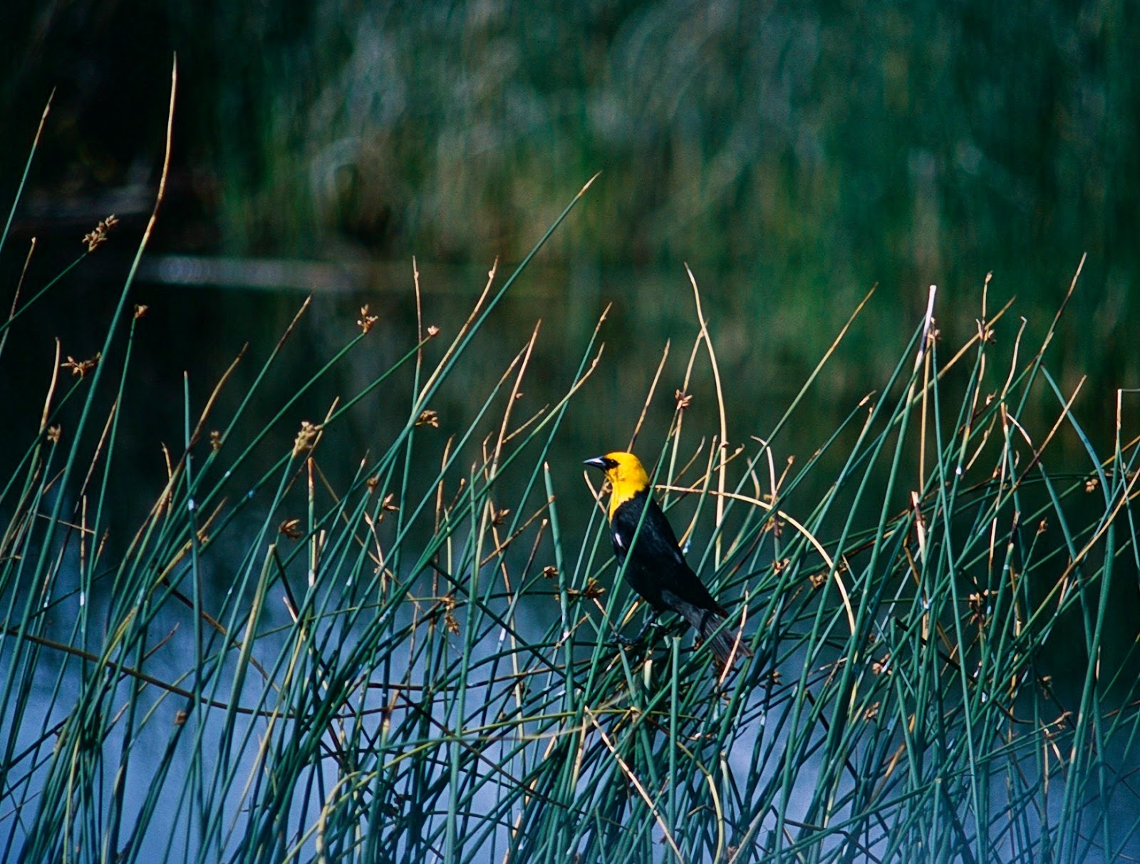
A Yellow-headed Blackbird sings from the reeds.


Snowy Egret.


A Great Blue Heron,  hoping to catch a fish.


White-faced Ibis stroll the marsh.


         The red stones found here were actually garnets and some of them still exist in the area.  If you go in search of the precious stones be aware that most of them are only a few millimeters in diameter.  But whether you're seeking garnets—or just one of the loveliest spots in North America—don't miss this gem of a place.

South Ruby Campground, nestled at the base of the
Ruby Mountains, is the perfect base camp for exploration
of the surrounding area.


Monday, June 20, 2016

Nevada Beyond the Neon: Berlin-Ichthyosaur State Park

         I nominate Berlin-Ichthyosaur for America’s oddest-named state park.  However, considering that many state parks are named to celebrate either history or scenery—Fremont Indian and Kodachrome Basin State Parks in Utah, for instance—perhaps this remote Nevada state park’s appellation suits it perfectly.

         Let’s break down the park’s unusual hyphenated name and unearth the linkage between the two.  

First, Berlin: 
         Given the chance to strike it rich from precious metals mining in the late 1800s, a town and all its infrastructure materialized before you could say “failed gold and silver mine”.  The town of Berlin, with it’s less-than-successful production, was born and died in little more than a decade between the late 1890s and early 1900s.  
         The townsite remained largely ignored for 50 years before being established as a state park in 1957.  Today the park service maintains Berlin in a state of “arrested decay”.  

         The Berlin ghost town tour is a self-guided journey into the past, through old mill sites and homesteads.
         The miners left in a hurry when the mills closed, without looking back or taking the time to pack.  Furniture, bottles, canned goods, cooking utensils, tools—even a jar of rattlesnake tails—all were left behind in their cabins.  Only in a state as dry and sparsely populated as Nevada could these treasures be preserved for visitors to enjoy and discover decades later.

Berlin Townsite.  The buildings from over 100 years ago are
well-preserved.  Notice the long and lonely entrance to the park.


The townspeople even left their cars intact!


Second, Ichthyosaur:
         A vast inland sea once covered most of the state of Nevada.  Inhabiting this sea were giant creatures, part fish and part lizard.  The sea lizards hung around for 160 million years or so, through the Mesozoic and Jurassic periods, becoming extinct during the late Cretaceous period.  
         Their bones were covered by thousands of feet of mud and slime, which later hardened into shale and then uplifted.  For tens of millions of years the shale eroded, exposing the prehistoric fossilized bones.  

         Enter those gold and silver miners, a few of whom discovered "rocks" shaped surprisingly like bowls.  You guessed it.  The peculiar rocks, used by miners as water dishes for their dogs, were later identified as vertebrae from the long-ago fish-lizards. 

         Dozens of fossilized ichthyosaur skeletons have been excavated near Berlin and thus these two historic sites—one of them 100 years old and the other 100 million years old—are explicitly linked.

The 60-foot long Ichthyosaurs were abundant and were the
largest animals of their time.


         Odd name or not, Berlin-Ichthyosaur State Park is well off the beaten path but worth a visit if you’re traveling through central Nevada.

Up the road from Berlin townsite the park
provides fourteen delightful campsites
with sheltered picnic tables.
A quarter mile nature trail leads to the fossil quarry.


Friday, June 3, 2016

Nevada Beyond the Neon: Great Basin National Park

         Mention Nevada and most people think of Las Vegas, that pulsing, energetic disco ball of a city.  By contrast, Nevada’s backcountry is relaxed and quiet, a place where the pace is not feverish disco but leisurely waltz, where light is provided not by pulsating strobes but by the soft glow of the sun and the moon.

         One Day in America’s most recent post introduced readers to US Highway 50 in Nevada, called the “loneliest road in America”.   
         This post begins a series highlighting places to go and things to see and do when you leave the highway and enter the spaces in between, those landscapes of sweeping views, endless skies, and room to breathe.


         We’ll begin our tour of Nevada with Great Basin National Park.  If it’s solitude you crave, then this is the national park for you.  Located near the tiny town of Baker, the park is little-visited.  I’ll prove it to you by quoting this statistic, which divides annual visitation by the number of days in a year:  

Average # of visitors per day to Yellowstone National Park:  11,000
Average # of visitors per day to  Great Basin National Park:      250

         Don’t get me wrong, Yellowstone is a great park—especially in the off-season.  But Great Basin holds many treasures of its own, including:  

1)  Lehman Caves.  This geological wonder of highly decorated marble and limestone formations may be explored with a guided park service tour.  
2)  Wheeler Peak.  At 13,063’, this is the second highest mountain in Nevada.  An 8.6 mile round trip hike will take you to the summit and back.
3)  Bristlecone Pines.  These ancient trees, several thousands of years old, stand proudly along the 2.8 mile Bristlecone trail.
4)  Lexington Arch.  An uphill climb of 1.5 miles leads to this six-story limestone arch.

Lexington Arch update:  Please note that wildfires and mudslides along Lexington Creek Road have rendered the road to Lexington Arch trailhead all but impassable for the last several miles. The road is mostly on Bureau of Land Management (BLM) land and the BLM has no plans to improve it.  This has made the hike to Lexington Arch—previously a 3 mile round trip—into a more difficult (no shade) 7-10 mile round trip.   Contact a Great Basin National Park ranger for more details.

Classic basin and range territory.
View from the road to Great Basin National Park.

Close-up of Wheeler Peak on an autumn day.

View from the Glacier Trail, a continuation of the
Bristlecone Pine Trail.

A magnificent Bristlecone Pine.
This tree could be 3000-5000 years old.


Lexington Arch as seen from the trail on a snowy
November day.

Have I convinced you to explore Nevada beyond the neon?  I hope so.  This summer the national park service celebrates its 100th birthday.  If you have a must-see list of national parks, put Great Basin near the top of that list.  You won’t be disappointed.